
Synopsis of Natural Hazards
Synopsis of natural hazards involves the development of probabilistic or scenario-based deterministic methods to compare different types of risks. As a case study, the German Freestate of Saxony, where flood, storm and earthquake hazards dominate, is selected. Risk is calculated on the basis of hazard and vulnerability models and a building asset database. Different risks are compared by risk curves as well as by developing extreme scenarios at the municipal level.
Project description
Different types of natural hazards have caused enormous damage in Germany. Lots of people and their properties have been affected.
Each type of natural hazard varies in space, time and intensity and can thus cause different amounts of damage. Until now risk assessment for different types of natural hazards - including its components hazard, exposure and vulnerability analysis - have been carried out separately. To enable planners and decision-makers to make adequate decisions on risk reduction and loss prevention programs a synoptical view of all natural hazards in a region under study is necessary. One of the few comparative risk analyses is given by Grünthal et al. (2006).
The main goal of the project “Synopsis of natural hazards” is to develop appropriate probabilistic and scenario-based deterministic methods so that the risks originated from different hazards can be compared within a common framework. It will tell which area is most vulnerable to which hazard or which hazard leads to maximum losses in an area (Murshed, 2006).
Within this study, the Freestate of Saxony is selected as the pilot area, where three natural hazards - floods, earthquakes, and wind storms - coincide. The quantitative risk analyses will be carried out for residential buildings at the municipal level taking into consideration all factors that contribute to the risk namely hazard, exposed elements and vulnerability. To keep the analysis consistent and comparable, the risk estimations will be done within a common range of annual probabilities and on a common database about the assets of residential buildings that is provided by Kleist et al. (2006).
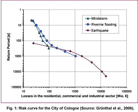
Different risks will be plotted as risk curves into a damage-frequency graph per municipality which enables a quantitative comparison of risks at different probability levels (see Fig. 1). As derivatives of the risk curves, the Probable Maximum Loss (PML) and the Average Annual Loss (AAL) will be calculated per hazard type for all Saxonian municipalities. To allow for appropriate disaster management strategies, extreme scenarios will be developed as well. Finally, a GIS-tool will be developed for the spatial representation of the risk curves and their derivates as well as for the visualization of different scenarios.
Publications
| Murshed, S.M. | Synopsis of natural hazards in Saxony | Presentation on CEDIM Workshop, November 2006, Potsdam |
| Grünthal, G., Thieken, A.H., Schwarz, J., Radtke, K.S., Smolka, A., Merz, B. | Comparative Risk Assessments for the City of Cologne - Storms, Floods, Earthquakes | Natural Hazards (2006), 38 (1-2): 21-44 |
| Kleist, L., Thieken, A. H., Müller, M., Seifert, I., Borst, D., and Werner, U. | Estimation of the regional stock of residential buildings as a basis for comparative risk assessment for Germany | Nat. Hazards Earth Syst. Sci., 6, 541-552 | » Link |
| Tyagunov, S., Heneka, P., Stempniewski, L., Zschau, J., Ruck, B. and Kottmeier, C. | CEDIM: From Multi-Hazards to Multi-Risks | Proceedings of the 1st ARMONIA conference, Barcelona, December 2005 |
| THIEKEN, A.H., B. MERZ, G. GRÜNTHAL, J. SCHWARZ, K. RADTKE, A. SMOLKA, M. GOCHT | A Comparison of storm, flood and earthquake risk for the city of Cologne, Germany. | Proceedings of the 1st ARMONIA conference, Barcelona, December 2005 |