
FDA - Reports
2026
|
Heat wave June 2026 | Western and Central Europe |
|
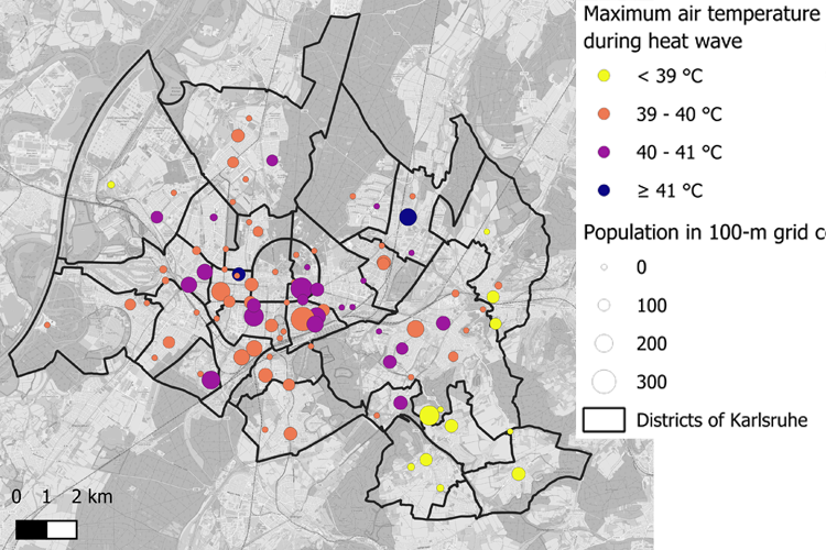 |
The June 2026 heat wave was one of the most exceptional heat events ever observed in Europe. Affecting large parts of Western, Central and Southern Europe between 13 and 29 June, it was characterized by record-breaking daytime temperatures, exceptionally warm nights and prolonged heat exposure. The event developed under a blocking-dominated atmospheric circulation, which enabled repeated transport of very warm subtropical air into Europe and sustained the persistent heat conditions. Numerous national and regional temperature records were broken, highlighting the extraordinary spatial extent and intensity of the event. This report investigates the meteorological drivers of the heat wave and examines its impacts across multiple natural and socio-economic sectors. Beyond the large-scale atmospheric circulation, the analysis considers the role of elevated Mediterranean sea surface temperatures, land–atmosphere interactions and associated heat-stress conditions. The study further assesses consequences for hydrology, the energy system, human health, and transport infrastructure, illustrating how prolonged extreme heat can generate cascading impacts across interconnected systems. Overall, the June 2026 heat wave demonstrates the increasing relevance of persistent heat extremes as a major climate risk for Europe. The event demonstrates how exceptional meteorological conditions translate into widespread environmental, infrastructural and societal impacts, underlining the importance of continued adaptation and improved resilience to future heat waves.
Report (English) (8 July 2026)
|
|
Wildfires January 2026 | South-Central Chile |
|
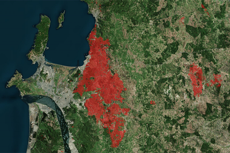 |
During the summer months, wildfires are common in Chile’s Mediterranean climate zones, varying considerably in size, speed of spread and impact. In January 2026, despite prior warnings from national authorities about exceptionally high temperatures between 16 and 18 January and the associated elevated wildfire risk, multiple fires broke out in the regions of Biobío, Ñuble and La Araucanía during and after this period. According to official provisional figures from the National Disaster Prevention and Response Service (as of 22.01.2026, 23:00), between 17 and 21 January a total area of approximately 40,000 hectares was affected, with 2,098 homes destroyed, 20,471 people displaced and 21 persons killed (SENAPRED, 2026). The largest contiguous fires occurred east of the Concepción Metropolitan Area and mainly affected the municipality of Penco, namely the Trinitarias fire (15,541 ha) and Rancho Chico fire (7,231 ha) (CONAF, 2026). The wildfires under consideration warrant closer analysis in that, despite not being the most extensive in terms of area, they resulted in comparatively high levels of damage to the population due to their occurrence at the wildland-urban interface (see Fig. 2a & b). In Chile’s recent history, comparable events include the Valparaíso hills wildfire of February 2024 (135 fatalities, approx. 11,000 ha burned) (Gobierno de Chile, 2024) and the large-scale fires in the south-central Chile in 2017 (12 fatalities, approx. 518,000 ha burned) (Pliscoff et al., 2020).
|
2025
|
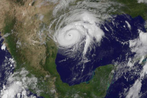
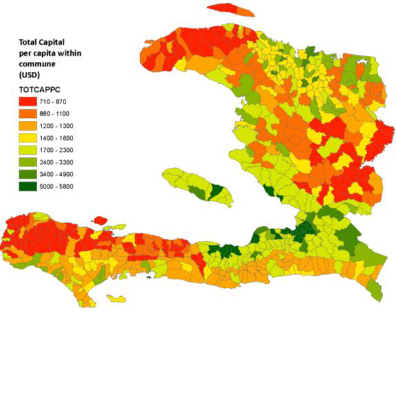
Hurricane Melissa (Jamaica, Haiti & Cuba, October 2025) |
|
 |
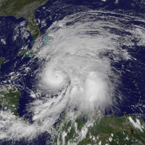
At the end of October 2025, Melissa formed as the fifth tropical cyclone of the 2025 Atlantic season that reached hurricane strength. Like two of its predecessors, Erin and Humberto, Melissa developed into a Category 5 hurricane, the highest category. Average wind speeds of 160 kt and gusts of up to 190 kt made Melissa one of the strongest tropical cyclones that ever occurred in the Atlantic Basin. Melissa reached the south coast of Jamaica on 28 October 2025, at its peak intensity and crossed the island as a Category 5 hurricane heading north. Melissa became the strongest tropical cyclone ever to hit Jamaica. Tied with the Labor Day Hurricane (1935) and Dorian (2019), Melissa thus topped the list of the strongest hurricanes to make landfall since 1851. Melissa was responsible for enormous amounts of rain, which caused devastating flooding, especially in Haiti, and claimed many lives. In Jamaica, the hurricane left a trail of destruction, with many buildings damaged. Most of the island was without power. As it continued northward, the hurricane gradually weakened, but as it passed over Cuba, Melissa was responsible for extensive damage again. Finally, Melissa moved across the Bahamas and passed Bermuda 250 km to the west before travelling into the vastness of the North Atlantic, where it lost its hurricane status on 31 October 2025. As an extratropical storm, Melissa headed towards European waters.
Report Nr. 1 (06 November 2025) |
|
Kamchatka tsunami (Pacific region, July 2025)
|
|
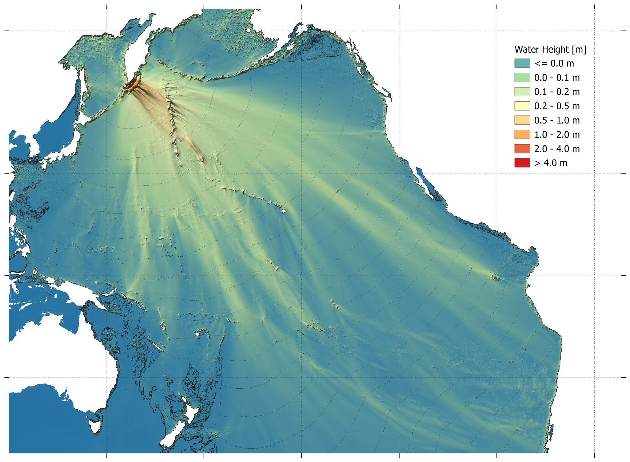 |
Shortly before noon local time on 29 July 2025 (23:24 UTC), the most severe earthquake since 2011 hit the Russian Kamchatka Peninsula in Northeast Asia. With a magnitude of Mw = 8.8, the ground shook for over 3.5 minutes, triggering a tsunami. In addition to local flooding, the tsunami spread across the entire Pacific Ocean within 24 hours, triggering tsunami warnings and reaching dangerous heights in coastal areas of Japan, the US (particularly Hawaii and the west coast), and the South Pacific, among other places. However, no significant tsunami-related damage is known to have occurred outside Russia.
Report Nr. 1 (31 July 2025) |
|
Mandalay Earthquake Myanmar 2025
|
|
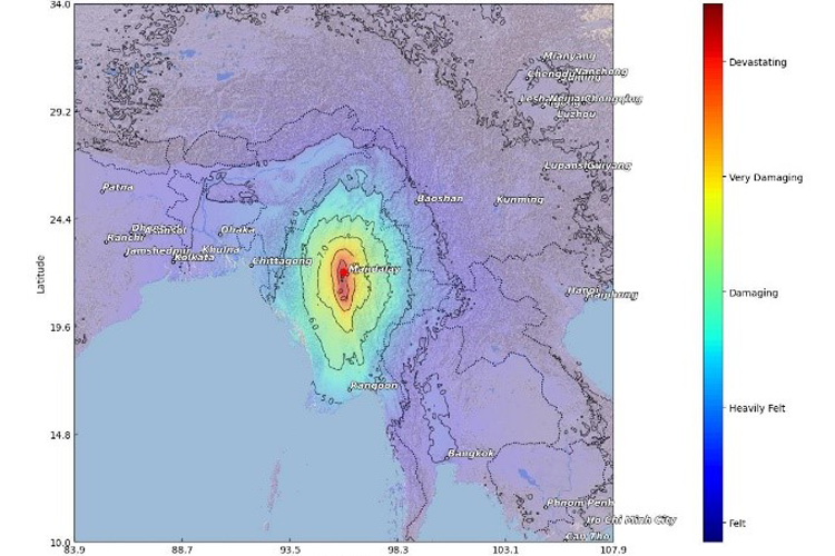 |
On March 28, 2025 at 6:20 a.m. UTC, a major earthquake with the magnitude 7.7 occurred near the capital city of Sagaing, Myanmar, at a depth of 10 kilometers. The earthquake was felt across much of Myanmar and in neighboring Bangladesh, India, China, and Thailand. It is estimated that up to 222.4 million people experienced the earthquake. While most experienced only light to moderate ground motion, approximately 8.1 million people live in areas where buildings may be damaged. Particularly at risk are 4.2 million people living in regions of potentially severe destruction. In addition, the long-period ground motion posed a particular threat to tall buildings, even over long distances as in Bangkok. The earthquake caused massive damage to Myanmar's transportation infrastructure. The two main bridges over the Irrawaddy River near Mandalay collapsed, cutting off key transportation links. Mandalay and Naypyitaw airports were also severely damaged, with parts of the Mandalay terminal collapsing and the Naypyitaw airport tower collapsing. In addition, many roads and bridges are impassable due to landslides and structural damage, hampering rescue and relief efforts. A high number of deaths, injuries and homeless are expected. The geopolitical situation in Myanmar is expected to further complicate relief efforts. In addition, large parts of the health and electricity sectors are likely to be damaged or out of service, further exacerbating the impact of the disaster. A total of 756 major healthcare facilities were affected. Of these, 99 hospitals and 50 clinics were located in areas of high seismicity and may experience significant operational problems. This earthquake fits into the long history of very strong earthquakes in this region along the Sagaing Fault. Similar earthquakes were recorded in 1839, 1912 and 1931. The time of day when the earthquake occurred may have helped to reduce the number of casualties, as a nighttime earthquake would have been associated with a significantly higher number of casualties. According to CEDIM model calculations, the estimated average number of victims is around 18,000, with a range between 5,600 and 45,000. Economic losses are estimated to be between $3 billion and $8 billion.
Report Nr. 1 (28 March 2025) |
2024
|
Exceptional precipitation and flooding in southern Germany (June 2024)
|
|
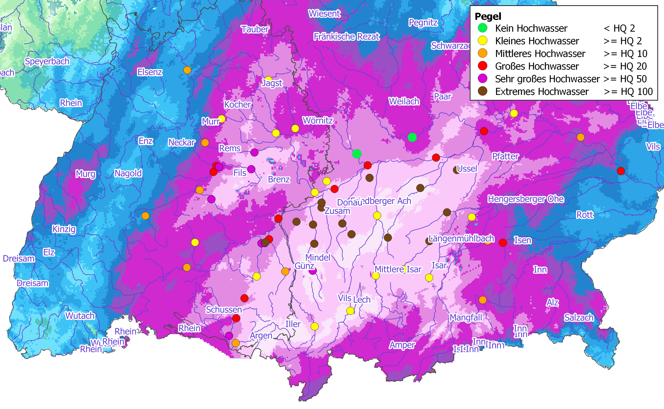 |
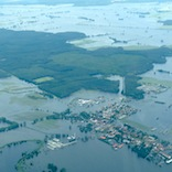
The second half of May 2024 was very rainy in Central Europe. From the 14th to the 16th, heavy rains caused flooding and high water in parts of southwestern Germany. At the end of the month, record rainfall in southern and western Bavaria and eastern Baden-Württemberg caused widespread flooding, especially along the right tributaries of the Danube from the Iller to the Isar. Within 48 hours, more than 100 mm of rain fell in many areas; within 120 hours, more than 200 mm was not uncommon. From Upper Swabia to the Donaumoos, the amount of precipitation corresponded to an event that statistically occurs less than once every hundred years. From a hydro-meteorological point of view, the heavy precipitation event had been predicted in advance by weather services and flood control centers. The German Weather Service (DWD) warned of flooding due to the incessant rain caused by the Orinoco depression. During the night of May 30 to June 1, 100 to 150 mm of rain fell in the Allgäu region as far as Augsburg, and further heavy showers and thunderstorms followed on June 3. Bavaria and Baden-Wuerttemberg were mainly affected, but also parts of other German states (e.g., Hesse), the Austrian state of Vorarlberg, and German-speaking Switzerland.
In a relatively small area in the foothills of the Alps near the Danube between the Iller and Isar rivers, extreme flood events occurred, especially in small catchment areas of up to 1,000 km, with peak discharges far exceeding previously measured events and HQ100 discharges. In addition, very large flood events up to HQ100 occurred in the surrounding regions (Lake Constance tributaries in Upper Swabia and Neckar tributaries north of the Swabian Alb). As a result of the inflows from the flood focus area, a large flood of the order of HQ10-HQ50 occurred on the Danube from the mouth of the Iller. The lower magnitude compared to the focus area can be explained by the fact that the alpine catchment areas of the Iller, Lech and Isar received comparatively little precipitation, some of which fell as snow. The water level of the Danube at Passau is still high at the time of writing, but is slowly receding. The consequences of the flooding are significant. Bavaria and Baden-Württemberg have been particularly hard hit by the flooding. Six deaths have been confirmed, and many people are still missing. In Bavaria, a state of emergency has been declared in 15 counties and three independent cities. There have been numerous evacuations, several dam bursts, problems with drinking water supplies, disruptions to mobile communications and power outages. There were also significant restrictions and closures of road and rail traffic in the affected regions. Navigation on the Rhine near Karlsruhe and on the Neckar between Heidelberg and Stuttgart was also suspended. Later, the entire course of the Danube in Austria was closed to navigation. In addition to the local emergency services, fire departments and water boards from other regions, as well as the Federal Agency for Technical Relief and the German Armed Forces, were deployed to combat the flooding. Thousands of people were evacuated as a precaution, and in many places people had to be rescued from their homes by boat and helicopter.
Report No. 1 (6 June 2024) |
|
Noto Earthquake (Japan; January 2024)
|
|
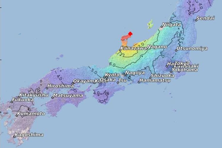 |
The 2024 Noto earthquake in Japan, with a magnitude of 7.5 Mw, occurred on 1 January 2024 at 16:10 local time - seven kilometers north-northwest of the coast of Suzu. The strongest intensity was observed on the Noto Peninsula near the epicenter and towards the Sea of Japan; the quake was felt throughout Japan, including the Tokyo area. A USGS landslide model shows a maximum slip of about 3.7 meters along the fault plane with a total length of almost 200 km. A tsunami warning was issued shortly after the earthquake, with a maximum wave height of 5 meters predicted for the Noto peninsula. The waves that eventually were mostly just under 1 meter, except in the town of Suzu, located in a small bay, where several boats were damaged and houses along the coast were destroyed. Eyewitnesses reported waves as high as 3 meters. Low wave heights were reported from the other coasts of the Sea of Okhotsk. CEDIM damage estimates (based on JMA/RL intensity data and Shakemap) average $4.9 bn (with a range of $2.3 bn to $11.1 bn). This estimate excludes significant indirect losses, but includes direct damage to buildings, infrastructure, and production. Most of the significant economic damage is concentrated on the Noto Peninsula, particularly in the cities of Wajima, Suzu, and Nanao.
Report No. 1 (3 January 2024) |
2023
|
Global heat wave (Northern Hemisphere; summer 2023)
|
|
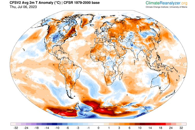 |
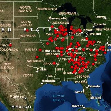
A consideration of the exposure of the population to the heat shows that in Germany around 7 million people were affected by daily maximum temperatures of over 25 °C (around 40 % more than the average 1980 – 1999). The number of people exposed to daily temperatures of 35 °C and more also doubled (to about 206,000 people). Compared to the summers of 2000 to 2019, the average daily heat exposure was only slightly above average. In the additional examined, such as Italy, Greece, Spain, the USA, China or India, a significant increase in heat exposure during the summer months compared to previous decades is also generally observed. In order to meet the challenges of extreme temperatures, government agencies have adopted heat action plans and implemented various adaptation strategies, including the creation of public fountains and water dispenser systems, which in Germany are best developed, especially in urban areas.
Report No. 1 (9 August 2023) |
|
Earthquake Kahramanmaraş & Elbistan (Turkey, Syria; Feb. 2023)
|
|
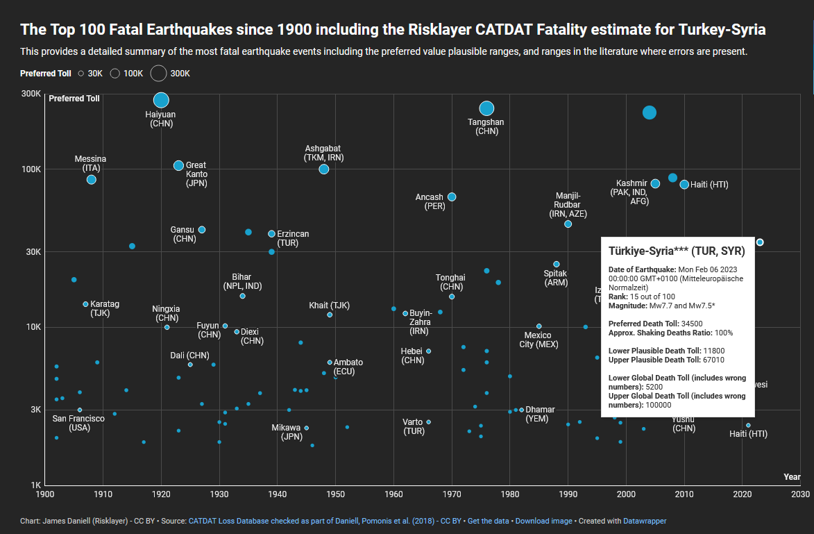 |
On 6 February 2023, two major earthquakes occurred in Turkey and Syria. The highest intensities were observed along an approximately 200 km long section of the East Anatolian Fault between Malatya and Iskenderun (Mw7.8), and along a second fault south of Elbistan (Mw7.5). Based on observations (large number of collapsed buildings and fatalities), intensities above IX were estimated. A large number of aftershocks additionally increased the damage and further increased the overall intensity. Pre-damaged buildings from the main earthquake could also collapse as a result of weaker aftershocks. Casualties and damage were also reported further away from the epicentre. The number of fatalities as a result of the second earthquake is lower, as many people were no longer in their homes at that time and were less likely to suffer damage. However, it can be assumed that the second earthquake contributed particularly to the increase in damage. Rapid damage estimates from the CATDAT model of CEDIM/Risklayer estimate the possible fatalities to be expected with a range of 11,800 to 67,010. The model projects total damage (including buildings and infrastructure) to exceed USD 10 billion. Looking at the event in a historical context, the CEDIM FDA Task Force estimates that it will be one of the 20 deadliest earthquakes (globally since 1900; as of 8 Feb. 2023). In addition, the people on site are suffering from the low temperatures in the freezing zone, which also further complicate the relief measures.
Report No. 1 (8 February 2023) |
2021
|
Flooding Central Europe (Germany)
|
|
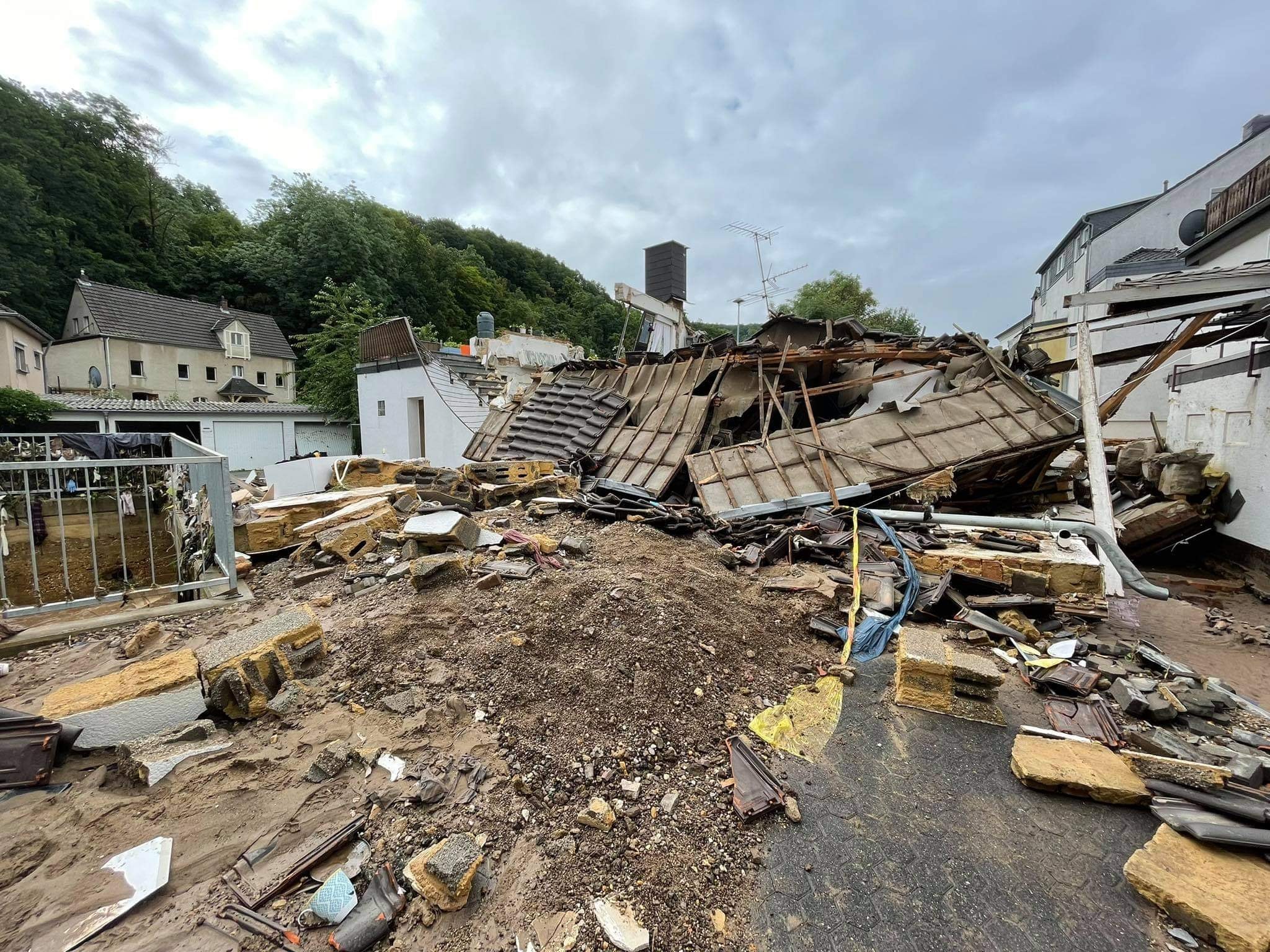 |
On July 13 and 14, 2021, huge rainfall amounts of 100 to 150 mm occurred over western Germany as well as in parts of Belgium and Luxembourg. Most of the precipitation fell within 15 to 18 hours. The two federal states North Rhine-Westphalia and Rhineland-Palatinate were particularly affected (Figure 2). As a result, the gauge on the Ahr River (Altenahr), for example, significantly exceeded its previous record of 2016 (3.71 m, runoff: 236 m³/s), although the gauging station failed completely due to flooding at a value of 5.05 m (runoff: 332 m³/s). Current estimates suggest a level between 7 to 8 m with a runoffbetween 400 to 700 m³/s for this event. From a meteorological perspective, several factors led to the extremely high precipitation totals. In addition, the highly structured topography of the affected region with partly deeply incised river valleys intensified the surface runoff, and the already nearly saturated soil further supported the situation. All this together finally led to a disastrous catastrophe that claimed at least 170 lives and injured 820 people (as of July 21, 2021) and caused disastrous damage to residential buildings and infrastructure. Initial estimates suggest insured losses of more than €10 billion, with total losses likely to be significantly higher as only around 37 to 47% of buildings have natural hazards insurance. In addition, the infrastructure is massively affected; the federal government expects €2 billion in damage to the transport infrastructure alone. In the past, there have already been two particularly significant flooding events in the Ahr valley: 1804 and 1910. A comparison with historical records suggests that the values of this year's event are to be ranked lower than for the flooding event of 1804 (estimate: ~ 1100 m³/s). In addition, it is estimated that the 2021 event may have been hydrologically similar in magnitude to the 1910 flood event (~ 500 m³/s). Since the hazard in current flood maps for the Ahr valley is based on discharge statistics based on temporally homogeneous available measurement series (in the case from 1947 onwards), however, the two historical events have not been considered in the hazard estimation so far and the current estimate of the 100-year flood (HQ100) for the Ahr river is "only" 241 m³/s.
Report No. 1 (21 Juli 2021)
Mohr, S., Ehret, U., Kunz, M., Ludwig, P., Caldas-Alvarez, A., Daniell, J. E., Ehmele, F., Feldmann, H., Franca, M. J., Gattke, C., Hundhausen, M., Knippertz, P., Küpfer, K., Mühr, B., Pinto, J. G., Quinting, J., Schäfer, A. M., Scheibel, M., Seidel, F., Wisotzky, C. (2023): A multi-disciplinary analysis of the exceptional flood event of July 2021 in central Europe. Part 1: Event description and analysis, Nat. Hazards Earth Syst. Sci., 23, 525–551, doi:10.5194/nhess-23-525-2023. Ludwig, P., Ehmele, F., Franca, M. J., Mohr, S., Caldas-Alvarez, A., Daniell, J. E., Ehret, U., Feldmann, H., Hundhausen, M., Knippertz, P., Küpfer, K., Kunz, M., Mühr, B., Pinto, J. G., Quinting, J., Schäfer, A. M., Seidel, F., Wisotzky, C. (2023): A multi-disciplinary analysis of the exceptional flood event of July 2021 in central Europe. Part 2: Historical context and relation to climate change, Nat. Hazards Earth Syst. Sci., 23, 1287–1311, doi:10.5194/nhess-23-1287-2023. |
2020
|
Storms Sabine & Victoria (Germany):
|
|
 |
Within just 10 days, several extreme low-pressure systems occurred in a very well-defined frontal zone on the North Atlantic. The core pressure of these storms sometimes reached record levels and the pressure dropalso reached record values. The storm fields not only covered the complete northwest of Europe, but also caused major problems in central Europe, as for example at Deutsche Bahn, which temporarily suspended long-distance traffic nationwide. Storm damage was recorded from Iceland to the Alps. On the British Isles, the depressions were also accompanied by higher precipitation amounts, which triggered flooding, especially in Wales. Extremely warm air masses reached Central Europe, allowing temperatures of around 20 °C during the night, which led to new decade and monthly records for the month of February at numerous stations in Germany.
Report No. 1 (28 February 2020) |
2019
|
Tropical Cyclone Idai (Southeast Africa)
|
|
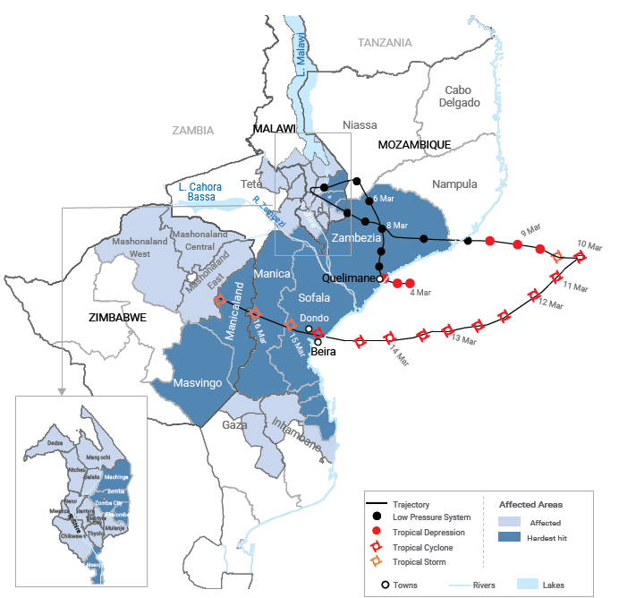 |
Over a period of 2 weeks, the long-lived tropical system IDAI hit large parts of South East Africa in the first half of March 2019. In the beginning, it was only the precursors of a tropical cyclone that led to severe flooding in Malawi. A few days later, however, the system passed over the warm waters of the Mozambique Canal and went through all the developmental stages of a tropical cyclone, finally becoming a full-grown cyclone with sustained winds of 195 kph and gusts of up to 280 kph. Shortly after its peak intensity, IDAI fell ashore in Mozambique during the night of 14 to 15 March 2019 a few kilometers north of the city of Beira (Fig. 1). Its slow propagation speed combined with destructive storm surges, heavy winds and an enormous amount of precipitation led to considerable damage and flooding in the region. The remains of the weakening tropical system subsequently caused further severe floods with landslides far inland in the east of Zimbabwe. A total of around 3 million people were affected by IDAI and its impacts. IDAI claimed several hundred lives and left hundreds of thousands homeless and displaced across the region. To date, IDAI has been the most devastating and deadly tropical cyclone in Mozambique's history.
Report No. 1 (30 April 2019) |
2018
|
Super Typhoon Mangkhut (Philippinen)
|
|
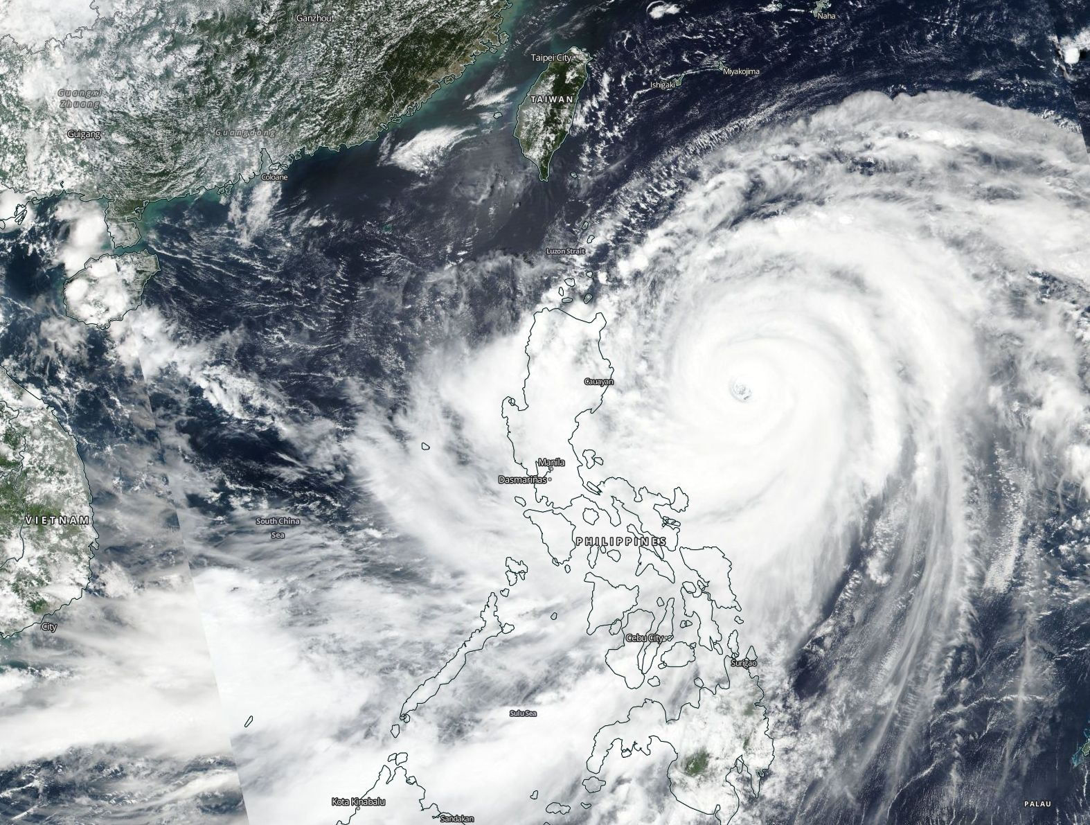 |
In mid-September, the world's strongest tropical system of 2018 so far, hit the northern main island of the Philippines, Luzon, and southern China. Super Typhoon Mangkhut fell ashore on Luzon on 14 September 2018 causing landslides and flooding and claimed many lives. Mangkhut was the first typhoon of the highest category since typhoon Megi in 2010 that struck the Philippines. The typhoon raged for nearly 10 days through the tropical western Pacific Ocean, its track had a length of 6600 km. At peak intensity Mangkhut hab sustained winds of 287 kph, gusts were as high as 352 kph. As was the case in the Philippines, extensive evacuation measures were also underway in southern China, where Mangkhut made landfall two days later as category 1 or 2 typhoon in Guangdong province. The storm center barely missed Hongkong and Macau, but the storm surge created new record water levels, fallen trees and major property damage. And for the first time ever, Macau, the Asian gambling capital, closed its casinos because of Mangkhut.
Report No. 1 (26 September 2018) |
|
Drought & heat wave, Germany
|
|
 © Marco Kaschuba |
For months, Europe was dominated by a large-scale pattern, which manifested itself in constant high pressure, especially over the north of the continent, and which, despite some variations, regenerated itself time and again during spring and summer. In such a blocking weather situation, Atlantic lows with cool, cloudy air and precipitation rarely find their way to Central Europe. April marked the beginning of an extremely warm period, which lasted until the middle/end of August 2018 and made the 4-month period from April to July 2018 the warmest period in Germany since recording began. With maximum temperatures close to 40°C, the German heat record was not broken, but new all-time records and monthly records were set at numerous locations in Germany. Extreme temperatures were also measured in the southwest, northwest and far north of Europe. The high temperatures were compounded by a drought that had already begun in February, which became increasingly severe with rising temperatures and advanced to a severe drought in Central Europe, which is currently still continuing. The consequences were and are sometimes dramatic: in addition to devastating forest fires in southern Europe and Scandinavia, there were major crop losses in Germany. In addition, almost all rivers have extremely low water levels in some cases, and all modes of transport (road, waterway, rail and air) have to contend with difficulties and failures, and damage has also occurred to infrastructure facilities.
Report No. 1 (18 August 2018) |
2017
|
Hurricane Irma, Caribbean and USA
|
|
 |
In the first half of September 2017, Hurricane "Irma" caused in the Caribbean and the US serious damage of over 50 billion US dollars. It hit the Leeward Islands, where individual were almost completely destroyed. In the US, there were historic floodings in the Jacksonville region and severe damage due to gale-force winds throughout the state of Florida. "Irma" set several records, among others the longest duration of wind speeds of at least 295 km/h in a tropical cyclone (37 hours).
Report No. 1 (8 September 2017) Report No. 2 (9 October 2017) |
|
Hurricane Harvey, Texas (USA)
|
|
 |
On 26 August 2017 Hurricane "Harvey" reached a minimum core pressure of 938 hPa and makes landfall as a category 4 cyclone with medium winds up to 215 km / h and peak winds to 260 km / h at 03:00 UTC near Rockport in the US state of Texas Country. This means the strongest landfall of a hurricane in the USA since Charley on 13.08.2004, which brought the fifth highest average winds (240 km/h) since the end of the 19th century. The first consequences were a lot of damage caused by hurricane, heavy rain, high waves and the storm surge (+2 m in Port Lavaca) until "Harvey" lost the hurricane status at 18:00 UTC.
Report No. 1 (29 August 2017) |
2016
|
Hurrikan Matthew, Haiti/Bahamas/Cuba/USA
|
|
 |
Hurricane Matthew developed over the Caribbean in the end of September and hit the western tip of Haiti with category 4 on the 4th of October. According to government statements, 545 died and 439 were injured. 128 people were still missing (status: 14th of October). In the following 24 hours, the hurricane hit the very east of Cuba and the Bahamas. There, he increased in intensity. Afterwards, the hurricane relocated towards the North East in small distance to the coast of Florida and Georgia. The center of Matthew reached the mainland of South Carolina as a category 1 hurricane for a short time on the 8th of October.
Report No. 1 (24 October 2016)
|
|
High Water/ Flooding in Southern Germany, May/ June 2016
|
|
 |
Thunderstorms with extreme precipitation intensities occured in Middle Europe from the end of May till the middle of June 2016. Locally enormous amounts of hail (at least small-grained) fell and even single tornadoes caused damage in a considerable degree.
Report No. 1 (20 June 2016)
Piper, D., Kunz, M., Ehmele, F., Mohr, S., Mühr, B., Kron, A., Daniell, J. (2016): Exceptional sequence of severe thunderstorms and related flash floods in May and June 2016 in Germany. Part I: Meteorological background. Nat. Hazards Earth Syst. Sci., 16(12), 2835–2850, doi:10.5194/nhess-16-2835-2016. |
2015
|
Earthquake, Nepal/China/Indien/Bangladesh
|
|
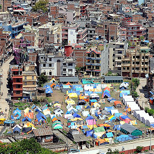 |
The 25 April 7.8 magnitude Gorkha earthquake and subsequent aftershocks, including the 7.3 magnitude earthquake in Dolakha, has caused devastation in Nepal on a scale not seen since the 1934 Nepal-Bihar Earthquake. According to the Government of Nepal, the Gorkha earthquake and aftershocks have severely damaged or destroyed nearly 900,000 buildings and approximately 2.3 million people continue to be displaced. A CEDIM-led research team conducted 284 household surveys in 177 locations spanning 27 Municipalities/VDCs and 7 districts.
|
2014
|
Typhoon 'Rammasun', Philippines/China/Vietnam
|
|
 |
Typhoon "Rammasun" (in the Philippines: "Glenda") hit land in the Philippines on the 15th of July at 07:00 UTC with categories 1-3. Gusts did reach a peak of up to 232 kph. The chinese and vietnamese mainland was reached at 18th of July at 06:30 UTC with category 4 in China and with categories 2-3 in Vietnam. Here, gust speed of up to 306 kph were measured (status: 30.07.2014, 12:00 GMT).
Report No. 1 (30 July 2014) |
2013
 |
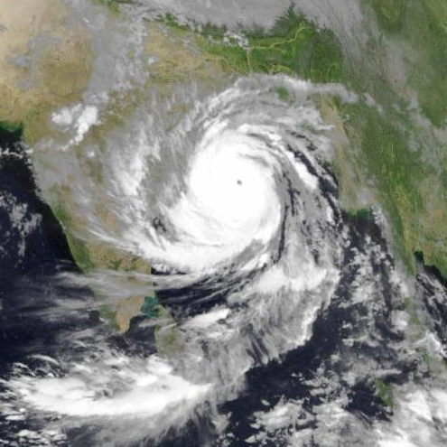
The category 5 typhoon made landfall near Guiuan on Eastern Samar at 07.11 at 20:40 UTC and hit with the strongest landfall wind speeds ever observed. Previously, the typhoon had hit the small nation of Palau causing some damage. Wind gust speeds reached a predicted 380 kph shortly before impact.The warm sea water and low wind shear has contributed to the maximum intensity of this typhoon before landfall. The central pressure was estimated 885 hPa (according Joint Typhoon Warning Center), which makes it only the 5th in 25 years in the Western Pacific to do so (Megi 2010, Flo 1990, Ruth 1991, Yuri 1991). The wind speeds have dropped significantly to around 150 kph approaching Vietnam and Southern China (Hainan). Typhoon dissipated 11.11. over China.
CEDIM Report No. 2 (13 November 2013) & Supplement (14 November 2013) |
|
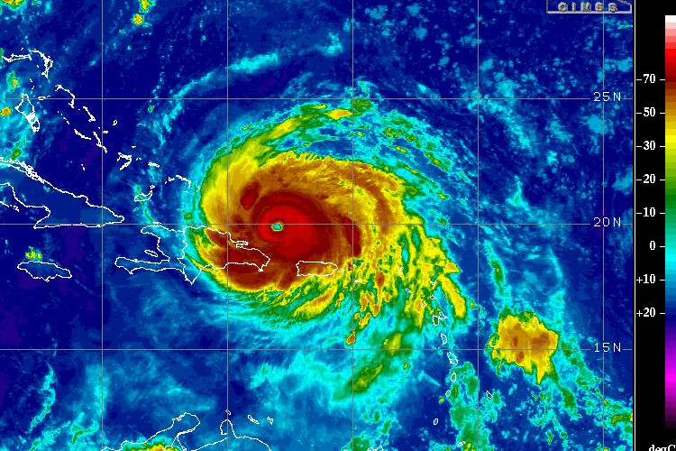
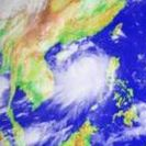
Supercyclon 'Phailin', India
|
|
 |
At the beginning of the second decade of October 2013 a very strong cyclone developed over the Bay of Bengal. Super cyclone 02B Phailin showed average wind speeds of up to 259 km/h making the storm a category 5 cyclone, the highest category according to the Saffir-Simpson hurricane scale. Phailin became one of the strongest tropical cyclones ever recorded over the North Indian Ocean. Phailins track led towards the northeast of India, where the tropical cyclone in the federal state of Odisha made landfall and caused enormous damage.
Report No. 1 (15 October 2013) Report No. 2 (22 October 2013) |
|
June Flood 2013, Central Europe
|
|
 |
Long periods of heavy rain, together with a unfavorable conditions, have caused the large-scale floods in Central Europe. This event has already exceeded in its extent the August 2002 flood and the summer flood of July 1954.
Thieken A.H., Bessel T., Kienzler S., Kreibich H., Müller M., Pisi S., Schröter K. (2016): The flood of June 2013 in Germany: how much do we know about its impacts? Nat. Hazards Earth Syst. Sci., 16, 1519–1540, doi:10.5194/nhess-16-1519-2016. Schröter K., Kunz M., Elmer F., Mühr B., Merz B. (2015): What made the June 2013 flood in Germany an exceptional event? A hydro-meteorological evaluation. Hydrol. Earth Syst. Sci., 19, 309-327, doi:10.5194/hess-19-309-2015. |
2012
|
Hurricane 'Sandy', North America
|
|
 |
From 25th October on, Hurricane "Sandy" first moved over the Caribbean and then turned in northern direction towards the East Coast of the U.S. and made landfall in New Jersey in the night from 29th to 30th October 2012. CEDIM investigates Hurricane Sandy and its impacts in a near-real time Forensic Disaster Analysis integrating the expertise of CEDIM researchers from various scientific disciplines: Meteorology, Hydrology, Engineering, Geography, Economics, Social Sciences.
Kunz, M., Mühr, B., Kunz-Plapp, T., Daniell, J.E., Khazai, B., Wenzel, F., Vannieuwenhuyse, M., Comes, T., Elmer, F., Schröter, K., Fohringer, J., Münzberg, T., Lucas, C., Zschau, J. (2013): Investigation of superstorm Sandy 2012 in a multi-disciplinary approach. Nat. Hazards Earth Syst. Sci., 13, 2579–2598, doi:10.5194/nhess-13-2579-2013. |
|
Drought U.S.
|
|
 |
CEDIM analyzes the drought and record temperatures in the U.S. in spring and summer 2012 and the impact of the drought. CEDIM researchers from different scientific disciplines contribute to the forensic analyses. A first report focusing on meteorological aspects of the drought and heat was released end of August 2012. An updated and extended report focusing also on possible loss and social vulnerability was released on Sepember 24, 2012.
Report No. 2 (24 September 2012) |
|
Earthquake sequence, Italy
|
|
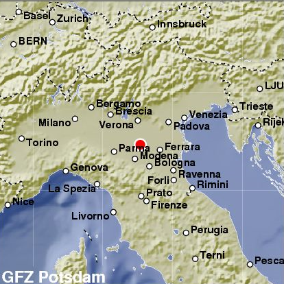 |
Two series of strong earthquakes hit the Emilia-Romagna region in northern Italy starting on Sunday, 20.5.2012 and on Tuesday 29.5.2012 respectively, affecting mostly the provinces of Ferrara, Bologna, Modena and Reggio nell'Emilia. The largest event had a moment magnitude of 6.1 and occurred on 20.5.2012 at 4:04 a.m. local time (GEOFON, see GFZ). It was followed by several aftershocks, two having a magnitude of more than 5. The main shock of the second series, having a magnitude of 5.8, happened on 29.5.2012 at 9:00 a.m. and was also followed by two events of more than magnitude 5 on the same day.
Report No. 1 (29 May 2012) |
2011
|
Van-Earthquake, Eastern Turkey
|
|
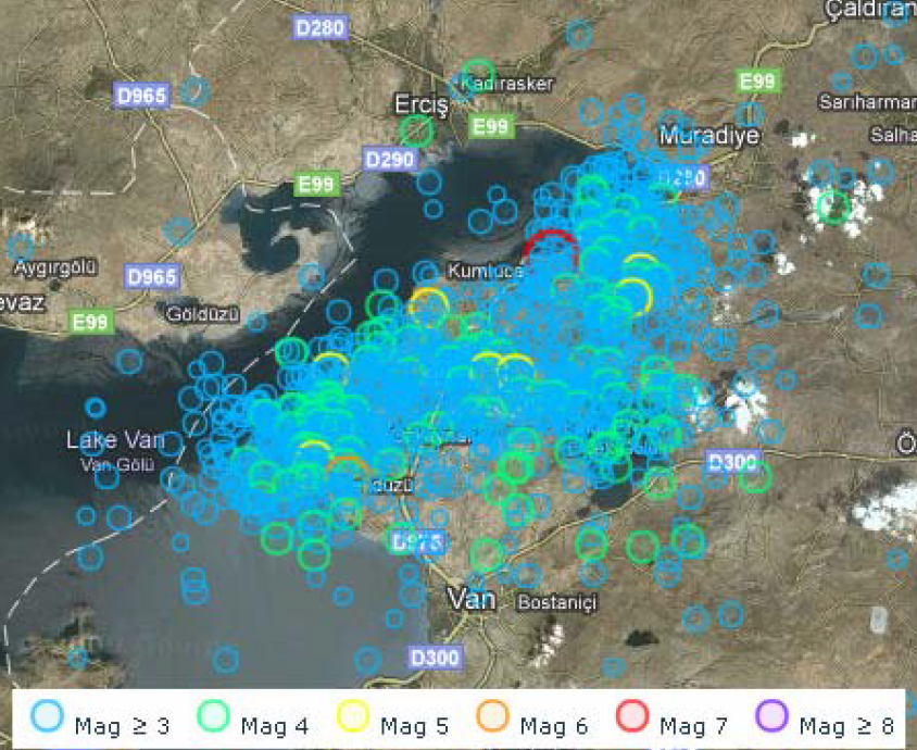 |
The M7.2 Van Earthquake (Eastern Turkey) of 23 Oct. 2011 served as a first example for a forensic approach. Our team consisted of a seismologist, three engineers, a social scientist, an economist, and a meteorologist. Four reports have been produced: immediately after the event on the situation (24.10), a situation up-date (25.10), one addressing shelter issues, in comparison to previous Eastern Turkish Earthquakes (26.10), and a comprehensive overview report (02.11).
|
|
Tohoko-Oki (Honschu) Earthquake, Japan
|
|
 |
On the 11th of March in 2011, an eartquake hit the east coast of Honshu (Japan) at 05:46:23 UTC. The Epicenter was located at 142.53 latitude and 38.23 longitude. The Hypocenter was located at 15 km depth. The earthquake had a 8.9 Mw Magnitude.
|