
Former Projects with CEDIM-Cooperation
|
Earthquakes are a serious threat for many European countries, particularly those around the Mediterranean Sea. In many cities exposed to high earthquake hazard, a substantial proportion of the population still lives in buildings that do not meet modern earthquake-resistant standards. Preventive actions, such as retrofitting of structures, are essential, but they are not sufficient and cannot be applied easily on a large scale. Real-time actions focussing on decreasing the physical vulnerability and exposure of populations are a viable way to reduce earthquake risk. The primary objective of REAKT is to improve the efficiency of real-time earthquake risk mitigation methods and their capability of protecting structures, infrastructures and populations. REAKT aims to develop methodologies that will enhance the quality of information provided by earthquake forecasting, early warning and real-time vulnerability systems, as well as establishing best practices for how to use all of this information in a unified manner. In order to be used effectively, such information needs to be combined into a fully probabilistic framework, including realistic estimates of the uncertainties involved, that is suitable for decision making in real time. From CEDIM, GFZ and KIT contribute to REAKT. REAKT’s Project Coordinator is Prof. Paolo Gasparini (AMRA - Analisi e Monitoraggio del Rischio Ambientale, Italy). |
|
A variety of natural extreme events, including earthquakes, landslides, volcanic eruptions, tsunamis, river floods, winter storms, wildfires and coastal phenomena, threaten different regions of Europe. This leads to populations suffering losses not only from individual hazards, but also from multiple events that occur in combination. In both their occurrence and their consequences, different hazards are often causally related. Classes of interaction inclued triggered events, cascade effects and the rapid increase in vulnerability during successive hazards. Effective and efficient risk reduction, therefor, often needs to rest on a location-based synoptic view. Planners and policy makers, and the scientists who inform their judgements, usually treat the hazards and risk related to such events separately from each other, neglecting interdependencies between the different types of phenomena, as well as the importance of risk comparability. Resolving this deficit will improve their ability to take risk reduction measures in a cost-effective way and in doing so, strengthen societies' resilience to natural disasters. |
 |
The overall objective of SYNER-G is to increase the understanding of the vulnerability of various societal elements at risk belonging to a system (city, region, lifeline network, etc.) and establish a European reference for seismic societal and physical vulnerability. In particular, SYNER-G aims to further develop appropriate fragility relationships for the vulnerability analysis and loss estimation of all elements at risk, for buildings, building aggregates, utility networks (water, waste water, energy, gas), transportation systems (road, railways, harbors) as well as critical facilities such as hospitals. The main contribution of SYNER-G is the development of a systemic framework and methodology which accounts for intra-relations between the components of each system, and inter-relations between the systems making up the infrastructure. Within the SYNER-G project, CEDIM is leading the work package on socio-economic loss and vulnerability. |
|
WEATHER - Weather Extremes: Assessment of Impacts on Transport Systems and Hazards for European Regions |
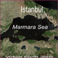 |
The research project EDIM was funded by the German Federal Ministry of Education and Research (BMBF) from 2007 to 2010. It was realised as a consortium of research and commercial organisations (see list below), coordinated by the University of Karlsruhe (TH). The aim of EDIM is the expansion of the existing earthquake early warning system of Istanbul (IERREWS - Istanbul Earthquake Rapid Response and Early Warning System) to the regional scale of the Marmara Region, as well as the significant improvement of the warning information in terms of its quality. |
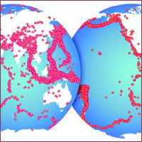 |
The Global Earthquake Model (GEM) is a public-privat partnership initiated by the OECD to build an independent standard for modeling, monitoring, and communicating earthquake risk worldwide. The Global Earthquake Model (GEM) will be the first global model for seismic risk assessment at a national and regional scale. In accordance with the principles of open-source development GEM will be developed as a versatile online tool, with open source code, open data - wherever possible - and a map-based graphical interface. Over 500,000 people died in the last decade due to earthquakes and tsunamis, mostly in the developing world, where the risk is increasing due to rapid population growth. But in many seismic regions, no hazard models exist, and even where models do exist, they are intelligible only by experts or available only to paying customers. We believe that better risk awareness can reduce the toll that earthquakes take, by leading to better construction, improved emergency response, and greater access to insurance. The Global Earthquake Model (GEM) answers this need, as an internationally sanctioned program initiated by the Organisation for Economic Cooperation and Development (OECD). » Project Page |
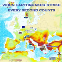 |
Earthquakes are a serious threat for many countries of Europe, particularly for those around the Mediterranean Sea. Early warning systems, based on the real time, automated analysis of ground-motion measurements, can play an important role in reducing the negative impact of such catastrophic events on densely populated areas and in mitigating the damage to strategic structures and lifelines. Europe is covered by numerous high quality seismic networks, managed by national and international agencies, including local networks specifically designed for seismic early warning around large cities such as Bucharest, Istanbul and Naples. |
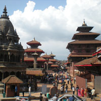 |
In collaboration with the South Asia Institute Heidelberg (SAI), CEDIM is working on a new project under the Heidelberg-Karlsruhe Research Partnership (Heika). The integrative approach to risk assessment is concerned with the Kathmandu Valley as a case study of a region of rapid urbanization. Both physical damage and socio-economic dimensions of vulnerability are combined to understand the interactions between natural hazards, technical systems and society. The results are used to develop a methodology for integrated seismic risk assessment. |