
Human sensors: Integration and assessment of information from the affected population for flood disaster management
Introduction
For disaster management and rapid loss estimation, it is important to quickly gain an overview of disaster impacts and resulting losses. For this overview, information from different sources such as different sensors, satellite images or observation of rescue teams need to be combined and analysed in order to be useful for decision making in disaster management and for post-disaster event analysis. Until recently, observations of eye witnesses and affected people were not systematically included in disaster management and rapid loss estimation. However, such information can be an important contribution, in particular for disasters with a great spatial extend or when disaster parameters cannot be measured.
Aims
Workflow of the projectThe overall aim of this research is to make observations of the affected population usable for disaster management. Using rapid flood loss estimation as an example, methods for quality assessment of such observation are developed in this project. The main questions to be addressed are:
• Which required information can be supplied by the affected population with sufficient quality? How can this information be collected?
• How can the quality of this information be assessed and controlled?
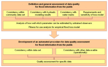
Figure 1: Workflow of the project
The research comprises two parts (see Figure 1). In the first part, the quality of observations from the public for flood events will be assessed using existing data from telephone interviews. The results of this study will be used in the second part of the research to develop an automated procedure for assessment of observations from the public to be used in a prototypical implementation of web-based data collection for flood events.
The quality assessment of existing data is based on telephone interviews with people affected by the flood in the Elbe and Donau river catchments in 2002 as well as the flood in the Elbe river catchment in 2006. In more than 2000 survey, the affected people provided information on flood parameters, private prevention measures and flood damages. In this project, data on inundation depth and flow velocity are used. Inundation depth is of particular interest, as it is the main flood parameter used in loss estimation. The data from the telephone interviews is analysed for consistency within the data set, consistency with measured inundation depths and with data from hydraulic modelling. Next, a fitness-for-use analysis is performed to determine whether the observations of the affected population are adequate for use in empirical flood loss modelling.
Based on these results, an automated procedure is developed that will allow to assess and use information provided by the affected population for rapid flood damage estimation in a web-based system that will be prototypically implemented.
Project status
Up to now, the data from the telephone interviews has been analysed for consistency within the data set, with measured and with modelled data. The results of the internal consistency check and the comparison with hydraulic modelling data show that the estimates of inundation depth deviate considerably from modelled values, but within the same scale as the modelled data deviate from measured inundation depths. The estimates of flow velocity by means of a verbal description and different indicators differ strongly from modelled values. However, since there are no measured values available, the reliability of the modelled and the estimated data cannot be judged. The comparison of the data from telephone interviews with measured inundation depths was performed using geostatistics. The results show that the deviation of the estimated water levels from the measured values is very similar to the deviation of the modelled from the measured values.
Using the municipality of Eilenburg on the Mulde River as an example, which was heavily flooded in the 2002 flood, the fitness-for-use of the observation of the affected population for empirical flood loss modelling was analysed. The results show that the damage estimates using the modelled, the measured and the estimated water levels differ only slightly. The deviation from reference data is higher, but due to inherent uncertainties in flood loss estimates, these values can still be considered useful for rapid flood damage estimation.
Outlook
After the assessment of the existing data from telephone interviews, currently an automated method for quality assessment is being developed for use in an web-based application for rapid flood damage estimation. Simultaneously, the results are written up in a dissertation.
Publications
| Poser, K.; Dransch, D. | Volunteered Geographic Information for Disaster Management with Application to Rapid Flood Damage Estimation. | Geomatica, 64(1), 89-98, 2010 |
||||
| Poser, K., Kreibich, H., Dransch, D. | Assessing volunteered geographic information for rapid flood damage estimation. | Proceedings of the 12th AGILE International Conference on Geographic Information Science: Advances in GIScience, 2009 | ||||
| Kreibich, H., Poser, K., Haubrock, S. | Web-based data acquisition of flood affected people. | Geophys. Res. Abstr., 10, EGU2008-A-12167, 2008. | ||||
| Poser, K., Kreibich, H., Dransch, D. | Humans as sensors: assessing the quality of information from the public for rapid flood estimation. | In: Pebesma, E., Bishr, M., Bartoschek, T. (eds.), Proc. of the 6th Geographic Information Days (GI-Days), June 16–18, IfGI prints, 117-122, 2008. |