
Project Descripition
Vulnerability of critical road infrastructure is increasingly gaining awareness in the field of transportation planning research. Natural hazards, such as earthquakes and floods, threaten the road infrastructure and thus the society depending on them. In the context of evacuation strategies the communities themselves are being focussed upon.
The KRITIS project founded by CEDIM targets the aspects of road infrastructure vulnerability mentioned above as a joint research project of the IPF (Institute of Photogrammetry and Remote Sensing, KIT) and IfR (Institute of Regional Science, KIT).
Within the IPF subproject a generic, multi-scale concept is being developed to analyse the vulnerability of critical road infrastructure. This concept follows a modular approach: Its basic module evaluates the accessibility of emergency facilities by calculating an accessibility and remoteness index (ARI). Additional modules provide the opportunity to calculate the index based on a grid and to generate a degraded network scenario. The model has already been applied to the Maule region in central Chile (see Figure 1). Additional modules will be realized and thereupon linked to the basic module.
The project utilises OpenStreetMap data as basis for the road network and emergency facility location. An exemplary implementation uses the open source software PostgreSQL, PostGIS and pgRouting.
The following tasks are handled at the IPF:
- Integration of social parameters for the interaction and linkage between humans and critical road infrastructure in a disaster case (cooperation with IfR)
- Development and implementation of a simulation concerning disaster-following consequences on road infrastructure. Possible disasters include tsunamis, earthquakes and floodings (cooperation with other CEDIM partners)
- Development and implementation of further vulnerability indexes
- Development and application of an index for intra-urban road infrastructure
Within the IfR subproject, the specific conditions and influencing factors at the local level are investigated, employing the models developed by the IPF. The main focus of the IfR-team is on the qualitative and quantitative empirical social research. Human behavior during the evacuation before a disaster event is analysed by taking these methods into account. Hence, specific local data of selected study areas in central Chile is collected using standardised questionnaires, expert interviews and focus group interviews. The results of the questionnaires represent the data base for the IfR subproject and are included in processed form into the IPF models as input parameters.
The IfR is responsible for the following tasks:
- Investigation of the evacuation behaviour among the affected society, especially regarding the following questions:
- Which routes are being used in case of a disaster?
- Which means of transport are being used?
- Investigation of influencing factors on evacuation behaviour
- Investigation of the specific framework conditions
- Identification of critical edges and nodes in the road infrastructure during past disaster events using socio-scientific methods
The joint research project is supposed to provide a decision-aid tool for regional planning of a road infrastructure. Furthermore, nodes and links in the road network that are particularly vulnerable in case of a disaster are to be identified. This will enable the disaster management to react strategically in the affected regions.
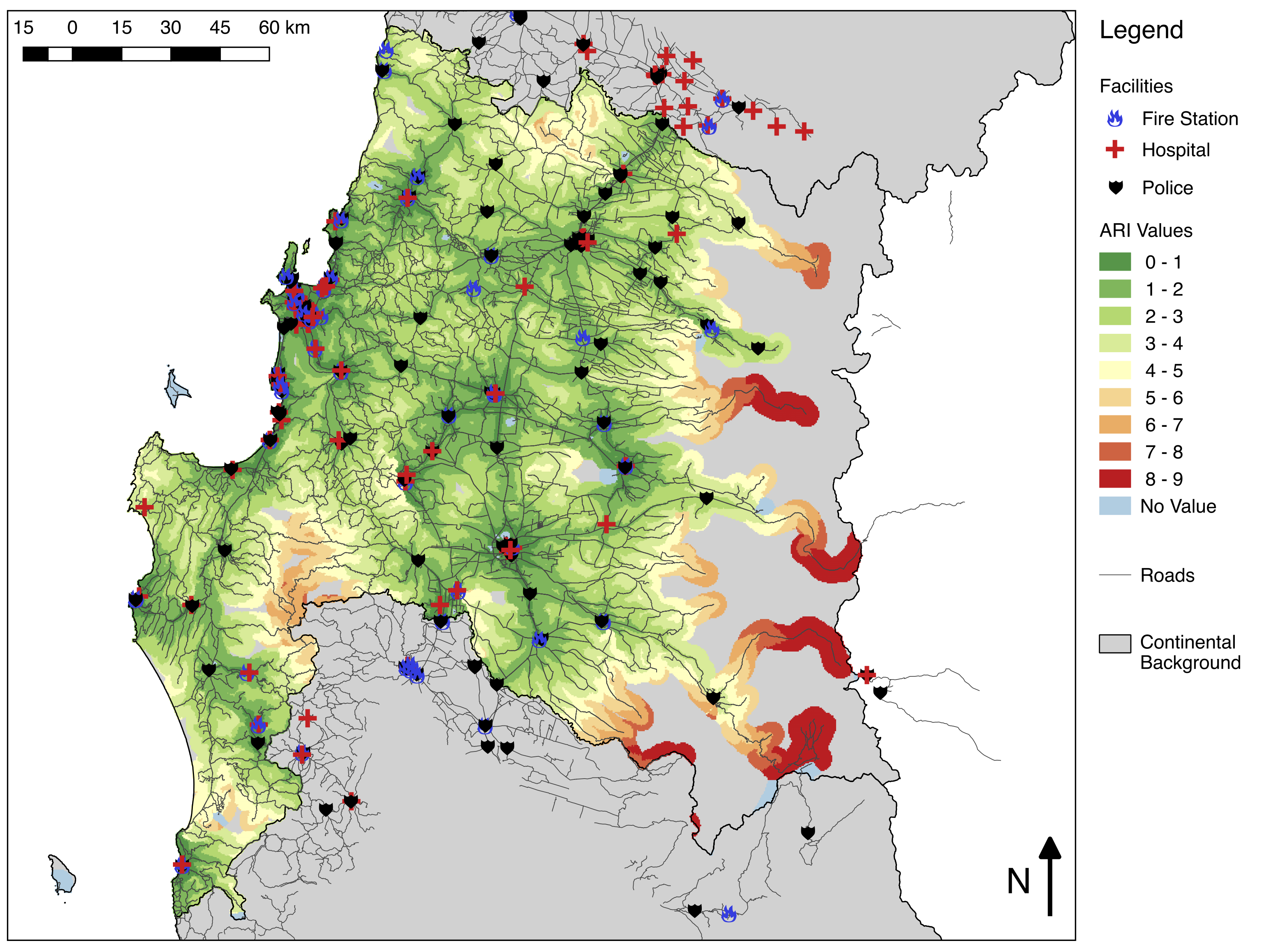
Figure 1: Accessibility and Remoteness Index for the Bìo-Bìo region in central Chile (500 x 500 m grid).
Green symbolises a high accessibility, red a high remoteness.