Former CEDIM Projects
|
Causal Loss Analysis
|
|
 |
Immediately after a hazard impacts a population, there are many important questions raised about the level of impact and the emergency response needs. Immediate response is often required before complete data are available. The causal loss analysis project focuses on creating methodologies to estimate and identify the key indicators and root causes in the immediate impact of a major event in terms of building damage and homelessness/shelter needs based on widely available data. This allows for the quantification of the scale of the disaster for response.
|
|
Convective Wind Gusts (ConWinG)
|
|
 |
Due to their local-scale nature of severe convective storms and an inadequate covering of measurement stations of the German Weather Service (DWD), there was a considerable lack of knowledge regarding the spatial and temporal distribution of those events. Against this background, the interdisciplinary project "Convective Wind Gusts (ConWinG)" was initiated at IMK-TRO and at the Institute of Hydromechanics (IfH) for a few years in order to investigate these phenomena more in detail. go to project
|
|
Croudsourcing
|
|
 |
In case of natural disasters, modern sensor networks provide high quality data. These measurements, however, are only mapping disjoint values from their respective locations for a limited amount of parameters. Using observations of witnesses represents one approach to enhance measured values from sensors ("humans as sensors"). These observations are increasingly disseminated via social media platforms such as Facebook, Twitter, Youtube and Flickr. Every user of these social networks can be regarded as a mobile, virtual sensor ("social sensor"). These "social sensors" offer several advantages over common sensors, e.g. high mobility, high versatility of captured parameters as well as rapid distribution of information. Moreover, the amount of data offered by social media platforms is quite extensive. On the other hand these data are often subjectively influenced by the observer and of varying quality and quantity. Methods and techniques, which identify appropriate information, need to be developed to enable the usage of social media data for applications in disaster management. The project's goal is to gather data from social media platforms that can be applied for rapid damage estimation in combination with common sensors.
|
|
Dams and Seismicity – Technologies for the safe and efficient operation of water reservoirs (DAMAST)
|
|
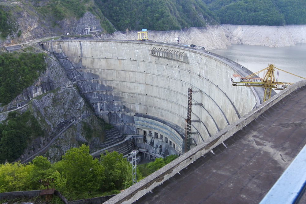 |
New dams are being built worldwide as part of the creation of a climate-friendly energy supply. In many places, natural or induced earthquakes, especially in combination with other extreme events such as heavy precipitation or landslides, are jeopardising the safety of dams and thus local populations. In the DAMAST project, German, Georgian and Armenian partners are examining the underlying processes as well as safety-relevant parameters of water reservoirs using the example of the Enguri Dam in the Caucasus. The project will develop transferable monitoring concepts for dams in tectonically active regions.
|
|
Database CBR
|
|
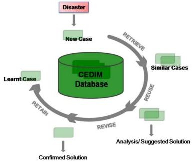 |
Within the „Forensic Disaster Analysis“ various institutes of KIT and the Geoforschungszentrum Potsdam are working together on an interdisciplinary basis. The knowledge database to be developed in this subproject has a cross-sectoral task since several subprojects intend to use it. The knowledge database is a combination of existing and event-specific databases containing historical disasters such as earthquakes, floods, or extreme weather events. This allows further usage of analysis tools in the frame of CEDIM FDA. In particular, we focus on case-based reasoning which is a methodology that utilizes similar past events in order to draw conclusions about a new and to a large extent unknown event. The historical database can either be extended by experts or new cases over the course of time.
|
|
Effects of Extreme Events on EMI-Systems
|
|
|
|
Facing the increasing probability of extreme events and their tremendous possible impacts on societies, it is inevitable to investigate their impacts on current and future energy, mobility and information systems. This is also more than valid, facing the aspect that through the network character of those systems, extreme events lead to cascading effects along its system-parts. That is why, natural disasters can have also severe impacts far away from their place of origin. The current globalization and strong interconnectedness around the world is also increasing this aspect. To assess the indirect impacts of natural events, two subprojects were implemented, dealing with supply chain vulnerability under consideration of global interconnectedness and changed consumer mobility requests in the aftermath of a disaster.
|
|
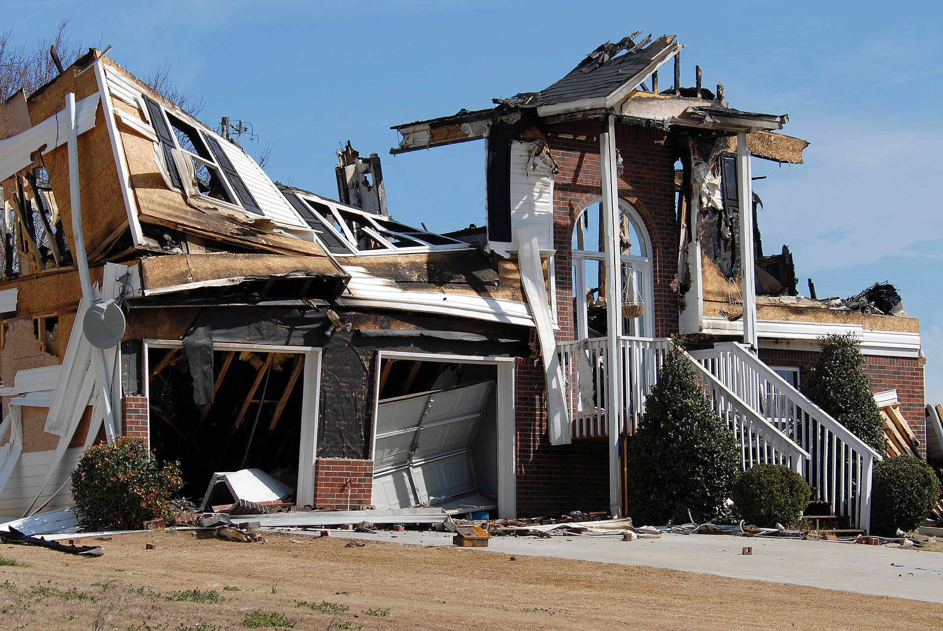
Energy risks toward 2025: Disaster risk and resilience assessment of renewable and traditional systems
|
|
 |
Energy systems are key to the recovery of a location post-disaster. Connectivity to internet, telephone systems, heat, cool, cooking, and many other processes are energy-system driven. Evacuation, business downtime and direct losses are all associated with energy systems. A change to the system, whether from natural disaster, terrorism or other effects can cause major delays and follow-on consequences for social and economic systems as seen through Tohoku 2011. With the world becoming increasingly reliant on electricity through use of the internet, a potential major outage during a disaster is a risk that will become more and more important to countries in the future.
|
|
Event based identification and assessment of bridge conditions based on radar sensors in combination with intelligent algorithms (ZEBBRA)
|
|
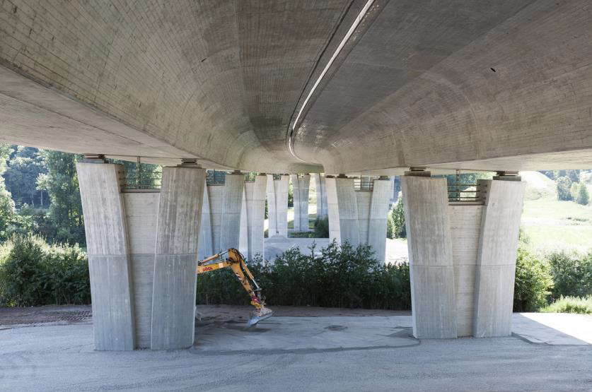 |
The increasing load on transport infrastructure by passenger cars and commercial vehicles as well as ageing of this infrastructure cause use restrictions and economic damages due to congestions and diverted traffic. The German highway network consists of about 40.000 bridges which are an important part of the critical transport infrastructure. Damage of the building structure is difficult to detect in an early stage, which is why the actual condition of a bridge often remains uncertain. The objective of the ZEBBRA-project is to develop a non-invasive, mobile and innovative approach for measurement and procedures in order to record and assess the bridge condition under normal operation. This approach is based on high-precision ground based radar sensors which measure the bridge vibration caused by passing vehicles. These data are then analysed with intelligent algorithms, and an assessment of the condition is carried out.
|
|
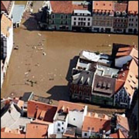
Flood Risk SV (FLORIS)
|
|
 |
Within the „Forensic Disaster Analysis“ various institutes of KIT and the Geoforschungszentrum Potsdam are working together on an interdisciplinary basis. The knowledge database to be developed in this subproject has a cross-sectoral task since several subprojects intend to use it. The knowledge database is a combination of existing and event-specific databases containing historical disasters such as earthquakes, floods, or extreme weather events. This allows further usage of analysis tools in the frame of CEDIM FDA. In particular, we focus on case-based reasoning which is a methodology that utilizes similar past events in order to draw conclusions about a new and to a large extent unknown event. The historical database can either be extended by experts or new cases over the course of time.
|
|
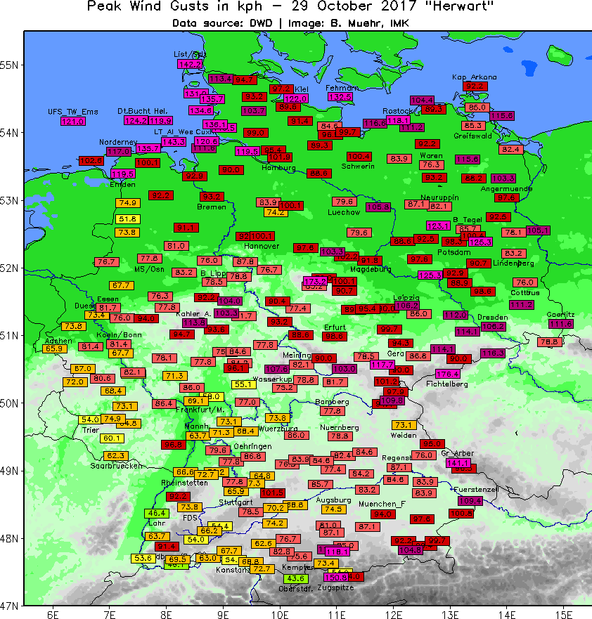
Forensic Prediction and Analysis – Rapid Loss Estimation of winter storms in Germany
|
|
 |
Feasible and routinely available techniques will be used to give an advance or real-time estimation of possible damage (amount of loss) before and during a winter storm event over Europe. With accurate station data (wind gusts) at representative locations weighted or unweighted storm indices will be calculated for past storm events. All this calculations eventually lead into a kind of “storm-MOS” (Model Output Statistics) that describes a storm event with reasonable certainty and precision and that allows to evolve a storm damage function. Once the storm occurs, the wind measurements at representative locations on the one hand and the model predicted wind gusts on the other hand provide the storm indices and the appropriate damage index. The data of all past and future storm events will be fed into a database and the parameters are: name, date, regions affected, model data, measurement data and loss data.
|
|
Global Dynamic Exposure
|
|
|
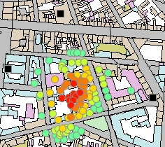
It is becoming more and more important to monitor risk in the context of natural catastrophes. With growing cities and changes in urban developments, risk is changing in complex ways as it is not scaling with population size but depends on changing building stock, resilience measures, and also city structure. Thus, monitoring of exposure and vulnerability indicators is providing the necessary tool to understand the dynamic nature of risk in urban environments. Because of the immense number and variety of buildings, exposure-, and vulnerability-related data, surveying exposure on the building-bybuilding level cannot be compiled by experts only.
|
|
|
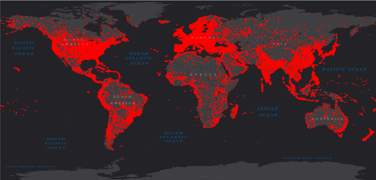
Global Tsunami Risk Modeling
|
|
.png) |
Since the devastating events of Sumatra in 2004 and Japan in 2011, tsunamis returned into the global memory and perception of natural disasters. Quantification of tsunami risk is difficult and many-faceted. During the last 20 years, various, mostly local models have been developed for the assessment of tsunami hazards and risk. But most of them show massive differences in terms of methodology, data assessment and interpretation. Thus, this project targets to develop a globally uniform and comparative tsunami risk assessment model.
|
|
Indicator system for assessing the hazard to infrastructure against extreme flooding
|
|
 |
As a consequence of climate change, occurrence of heavy rainfalls increases, leading to inevitable flooding. Considering the devastating effects of floods, their assessment is essential in order to mitigate the hazard. The main goal of the project is to develop the relevant indicators for large scale hazard and risk analyses based on a deepened knowledge of the dynamic processes and impacts of extreme events.
|
|
Information Gap Analysis
|
|
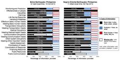 |
The quality of a disaster response can affect how severely a society is harmed by a disastrous event. While an efficient response can help to reduce casualties and suffering, a less efficient response may aggravate the situation. In order to include the disaster response as a potentially contributing factor to the overall disaster impact, a methodology has been developed to analyze disaster response in near-real-time.
|
|
Modelling Extreme Flood
|
|
 |
The aim research project is the development of a modelling system to quantify risks of extreme flooding in large river basins. In the system, computer models and modules are coupled together to simulate the functional chain: hydrology – hydraulics – polder diversion – dyke failure – flooding – damage estimate – risk assessment.
|
|
Methodology for (rapid) assessment of the economic impact of natural disasters on industrial companies and supply chains
|
|
 |
The project aims at developing a method that enables the near-real time assessment of economic impact (both direct and indirect) for all phases of a disaster. The developed method must therefore help decision makers to come up with a good decision that is founded on a valid basis quickly although the available information may be incomplete, uncertain, lacking or conflicting. Additionally, the method should be designed to guide support the search for further information by focusing on the most relevant or vulnerable aspects. At the same time, the model hast to be easily adaptable. In this manner, newly available information can be integrated rapidly. The analysis can then be enriched successively providing near real time (as the situation unfolds) more and more detailed levels of analysis and more precise results. Finally, it must be possible to quickly adapt the model to different information systems and infrastructures to ensure that first results can be determined shortly after any potential disaster, wherever it might happen.
|
|
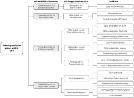
Resilience of urban infrastructures in the course of time
|
|
 |
The welfare of modern societies highly depends on the functioning of Critical Infrastructures (CIs) like power and water supply, transport and distribution systems. Thus it is desirable to gain a profound understanding on how disruptions of CIs for example caused by extreme weather events or terrorist attacks affect the vulnerability of a city - today and in the future. Detecting hidden or a priori underestimated interdependencies could help to identify enhanced strategies for crisis management and design patterns concerning robust future CI developments. For this purpose an Agent Based Modelling (ABM) approach, where CIs or CI components are modelled as agents, seems to be most promising.
|
|
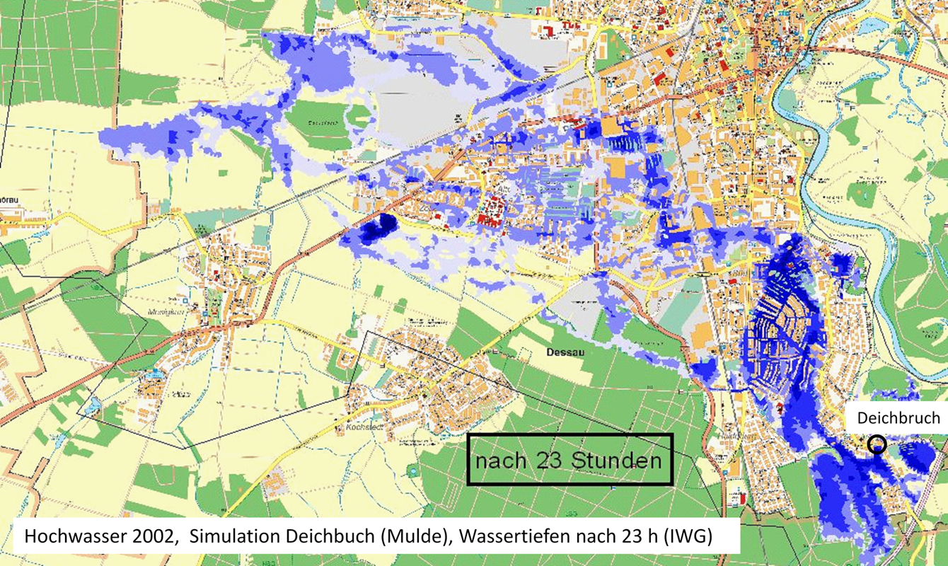
Rapid Flood Event Analysis
|
|
| |
Within the scope of “rapid flood event analysis” a methodology for the near real time analysis of large scale flood events in Germany will be developed. This comprises the compilation, analysis and evaluation of the hydro-meteorological and hydrological situation in the course of the event right up to the assessment of direct flood damages. On this basis, the event will be comparatively ranked into a catalogue of historic large scale flood events in Germany.
|
| Serial clustering of extreme events in Central Europe | |
 |
The occurrence of several extreme events within a short time period hits a society particularly severely. Furthermore, for insurers, the occurrence of several events within a year is more expensive than a single event of the same loss amount, since the net impact also depends on the number of distinct loss events. Moreover, catastrophe and risk models traditionally assume a constant time interval between extreme events, which leads to an underestimation of temporal (serial) clustering, i.e., clustered occurrence, and hence risk. An investigation into the causes of this combined occurrence and a forecast for the future is therefore highly relevant and the subject of this project.
|
|
Slip Distribution
|
|
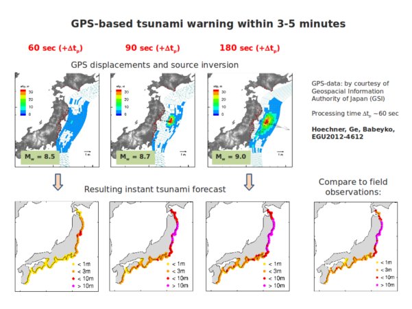 |
The goal of this project is to further develop and implement kinematic inversion techniques using displacement wave forms which include near-field terms in order to obtain a detailed description of the earthquake source within a short amount of time. One application, where rapid determination of slip distribution is crucial, is tsunami early warning. Quick and reliable assessment of earthquake magnitude avoiding saturation is essential for rapid shake-map simulation and loss estimation.
|
|
Transportation Interruptions
|
|
The overall goal is to substantiate and extend common methodologies of indirect loss assessment towards rapid loss estimation. Therefore this project contributes to a better understanding of economic losses of events harming transport systems. This project specifically aims to:
|
|
|
Urban Flush Floods and Sewerage (HI-CAM)
|
|
 |
The sub-project “Urban flash floods and sewerage” of Helmholtz-Initiative Climate Adaptation and Mitigation: two Sides of the same Coin (HI-CAM) aims to simulate and assess the entire effect chain: from extreme rainfall scenarios including expected changes and temporal clustering through inundation and flooding to resulting infrastructure damage to the effect of rainwater overflow to the impacts on water quality and ecology. The frequency and intensity of extreme convective rainfall in an urban area is statistically evaluated based on station and radar data. Focus will be on quasi-stationary convective cells locally producing largest rainfall accumulations. Spatial shifting of extreme rainfall patterns to the region of interest allows to estimate upper bounds of the extremes. Probabilistic precipitation changes for future periods will be quantified from an ensemble of high-resolution RCM. To better understand the temporal variability of the local-scale extremes, we will also investigate their relation to large-scale dynamics in terms of atmospheric blocking or teleconnections influencing serial clustering over periods of days to weeks, and how these conditions will change in the future.
|
|
User Oriented Visualisation
|
|
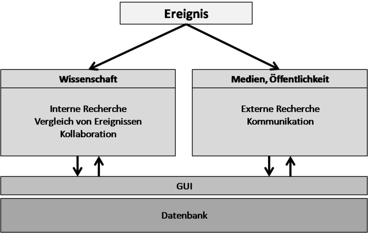 |
Within the new project “Forensic Disaster Analysis” (FDA), CEDIM started an interdisciplinary research initiative to analyze natural disasters and their impact in near real-time. Focus is the complex interaction between natural hazards, infrastructure and society. The aim is not only to help understanding a disaster in near real-time but also to identify the root causes of the event to derive implications for a long-term risk reduction. One important information source therefore are historical events.
|
|
Vulnerability and resilience of the critical infrastructure as exemplified by Chile
|
|
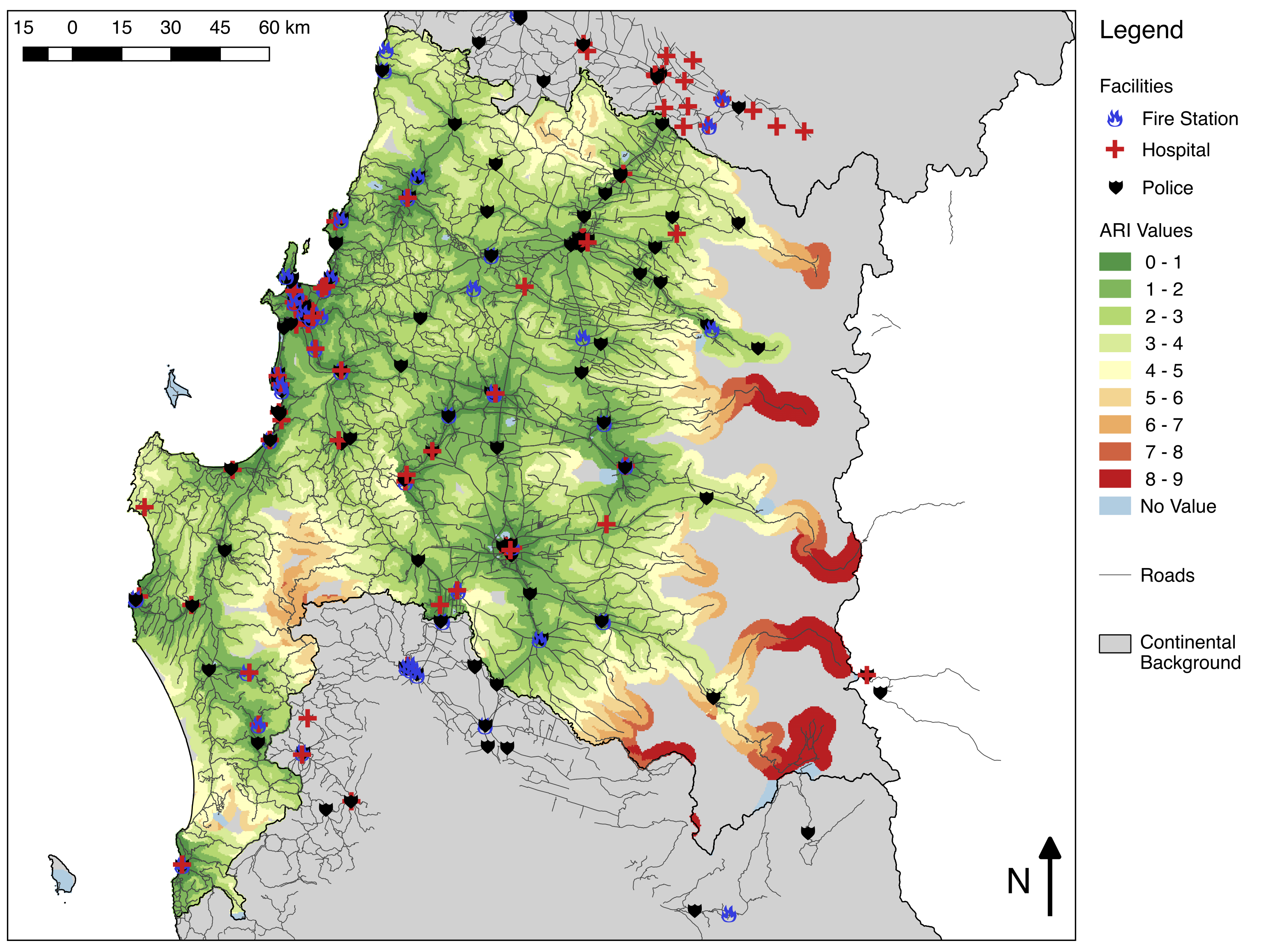 |
Natural hazards, such as earthquakes and floods, threaten road infrastructure and thus the society depending on them. On the one hand, the CEDIM-funded joint research project KRITIS investigates the evacuation behaviour of an affected society using qualitative and quantitative empirical social research. Therefore, specific local data of selected study areas in central Chile is collected using standardised questionnaires, expert interviews and focus group interviews. On the other hand, a generic, multi-scale concept is developed to analyse the vulnerability of critical road infrastructure. This concept follows a modular approach and evaluates the accessibility of emergency facilities by calculating an index as its basic module. The socio-scientific parameters gained in the field research are integrated with additional modules to the regional conditions in more detail.
|
|
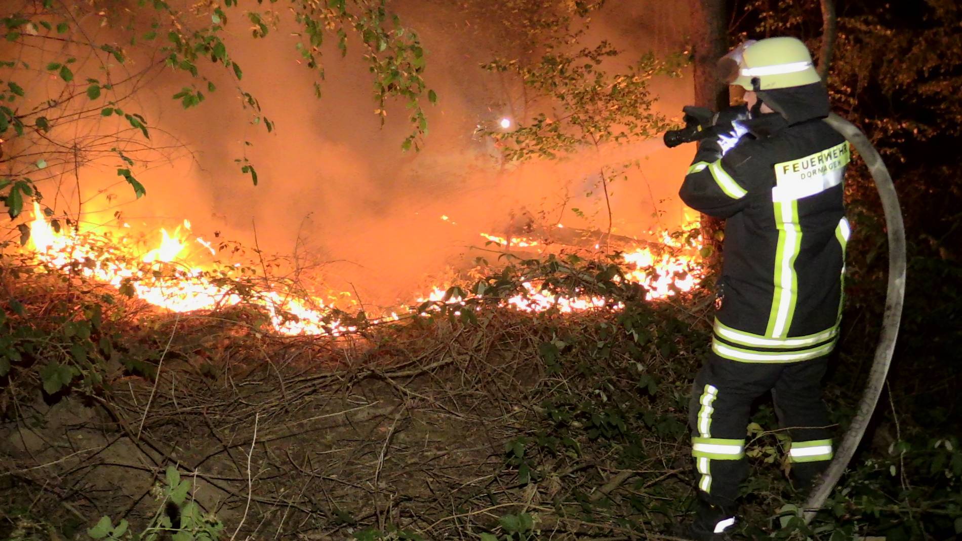
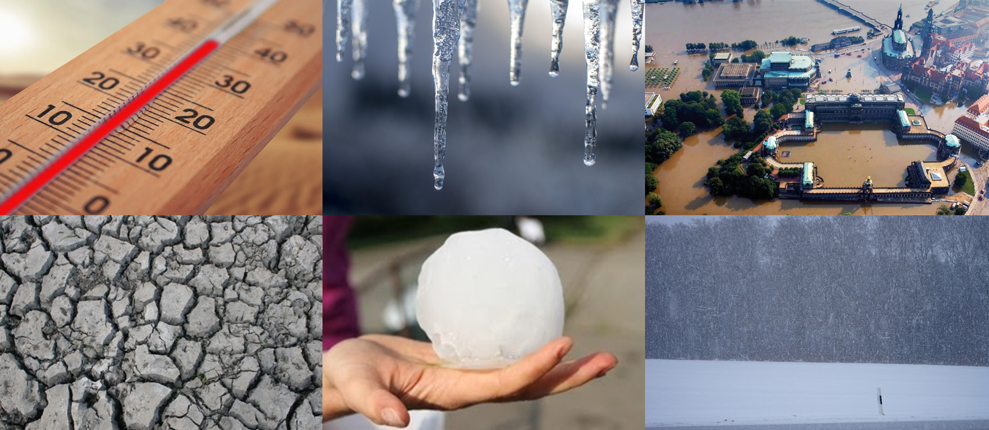
Wildfire risk in Southern Germany |
|
|
|
The combination of prolonged drought events in the summer months and human negligence leads to an increasing wildfire risk, also in Germany. In the past two years, the number of wildfires and the size of the fire affected area were comparatively high. In 2019 alone, burned forest area amounted to 2711 ha. This is the second largest fire affected area since the beginning of the German wildfire statistics in 1977. Risk assessments show that this trend is set to continue in the next decades. As forest ecosystems have essential supporting, provisioning, regulating and cultural functions in the field of ecosystem services, their protection and conservation are of increasing interest, especially in densely populated countries. In order to reduce the number of wildfires and fire affected forest area in the future, we want to develop suitable risk models or vulnerability functions to determine risks and forecasts that can help to derive measures for wildfire prevention.
|