Current CEDIM-Projects
|
Rapid Earthquake Impact Modeling
|
|
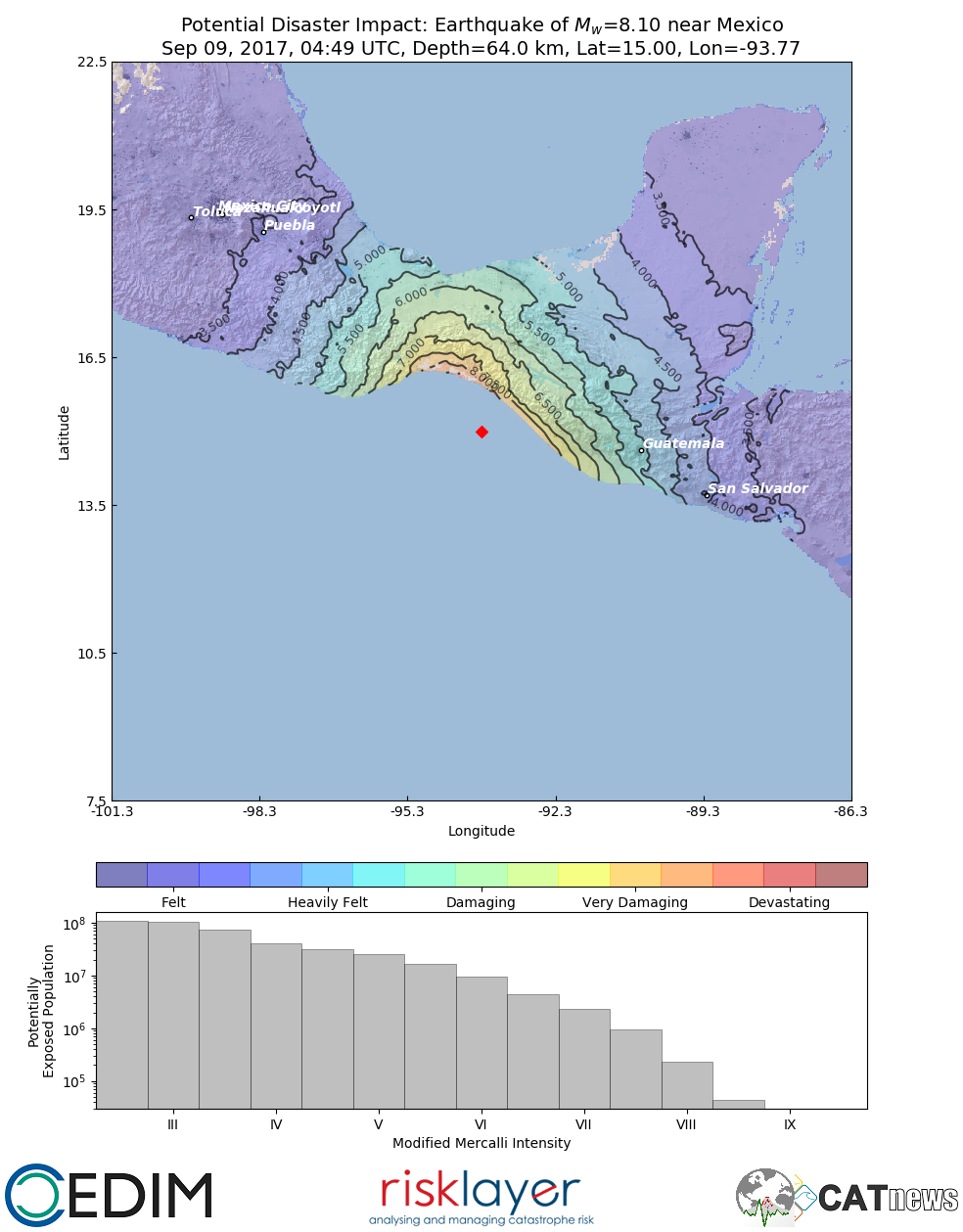 |
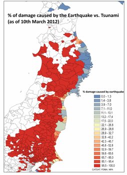
Earthquakes are felt every daily all around the globe. In some cases, damaging effects cannot be avoided and it is difficult, especially during bigger disasters, to estimate the actual impact. But first estimates of the earthquake intensity are important to estimate potential losses and the number of affected population. For this task, a system for disaster cartography has been developed to provide potential disaster impact maps within minutes after an event occurred. Such data can then be used e.g. for loss estimates or mitigation measures.
|
| Impact of recent and future drought events on river discharge and fluvial transport sector for the Rhine River | |
|
|
The Rhine River is Germanys most important inland waterway for transporting heavy goods and raw materials from and to the resident companies, with about 80% of the total market share for river transportation. Thus, restrictions on the navigability of the Rhine significantly impact the supply chains for the whole region, including several federal states. Interruptions in transport are mainly caused by high or low water levels in the Rhine River and its tributaries. For the former, extreme water levels are strongly influenced by widespread, intense precipitation in the catchment area, while for the latter, a lack of precipitation results in severe drought conditions and low soil moisture levels across the basin. In this project, we will focus on the impact of long-lasting drought events (e.g., 2018, 2022) on the river discharge and, thus, the navigability of the Rhine River in a changing climate using a high-resolution coupled atmosphere-hydrology modelling approach. The obtained information is exchanged with stakeholders to exploit the implications for river transportation and business interruption for resident companies along the Rhine River
|
|
Capturing the effects of drought and heat waves on forests in Central Europe
|
|
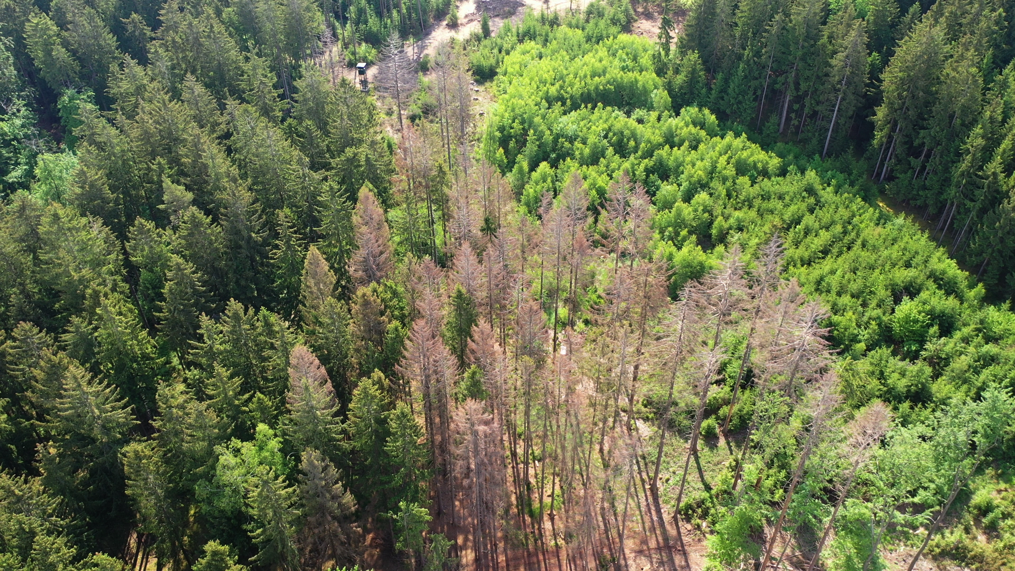 |
As a result of climate change, the frequency of summer drought events is increasing worldwide. The combination of drought stress and high temperatures can cause damage to trees and may result in tree death. The dry summers of 2018 and 2019 have severely damaged forests in large parts of Central Europe. As a result of these exceptionally hot and long drought events, many millions of trees have died, leading to substantial financial losses for forest owners. The size of the potentially affected area in Germany - and ultimately worldwide - is large and challenges terrestrial-based forest observations. Therefore, we want to combine measurement techniques based on remote sensing tools to identify and quantify stress-induced forest damage.
|
| Capturing the critical effects of heat waves in urban public spaces | |
|
|
High summer temperatures are to be expected worldwide due to global warming. Heat and especially long periods of heat can have a negative impact on human health. The impervious surfaces and other structural influences in cities further intensify this phenomenon and lead to significantly higher temperatures in urban areas compared to the surrounding rural areas, also known as the urban heat island effect, which can be observed worldwide, especially at night. Temperature extremes and periods of heat can be recorded (a) using on-site meteorological measurements (b) thermal indices derived from these measurements and c) social research methods with regard to personal thermal perception. The aim of the project is to record all three levels of observation and their interrelationships and to draw conclusions about the stress situation during periods of heat and possible discrepancies in perception.
|
|
Forensic Disaster Analysis
|
|
 |
In late 2011, CEDIM embarked on a new style of disaster research known as Forensic Disaster Analysis. In the new research program CEDIM Forensic Disaster Analysis (CEDIM FDA), CEDIM researchers will analyse disasters and their impact in near real-time. The core of CEDIM’s new style of analysis is to examine disasters in an interdisciplinary manner with a focus on the complex interactions between
|
| Potential and feasibility study on the extension of the use of dams in Baden-Württemberg for the real-time management of heat, drought and floods (HDH-BaWü) | |
 |
Floods and droughts seem to be dichotomous hydrological events: floods are rapid and short-lived, while droughts are slower but longer; flood protection requires empty reservoirs, while drought protection requires full ones. Reservoirs—particularly small and medium-sized retention basins—have thus far been built and operated in Germany primarily for flood protection. The increase in frequency and intensity of drought and heat waves in Germany during the recent decades suggests an expanded usage of these reservoirs. Thus, the ability of reservoirs for simultaneous flood, heat, and drought protection should be investigated. Structural, legal, economic, ecological, and in particular operational aspects are considered in a risk-based cost-benefit analysis for existing reservoirs in Baden-Württemberg. This project, a potential study for the expanded usage of flood reservoirs for heat and drought protection in Baden-Württemberg (HDH-BaWü), is executed in cooperation with partners in local administration (Landesanstalt für Umwelt Baden-Württemberg LUBW), industry (WALD+CORBE), and academia (Theodor-Rehbock-Laboratory for River Improvement at KIT).
|
|
Loss Assessment for Earthquakes
|
|
 |
Based on the huge flow of information via internet (focussing on earthquake-report.com) and building on the largest earthquake loss database available (CATDAT) and using indicator based evaluation methods, a structured picture of losses for earthquakes will emerge. They will be compared with other events based on tectonic, regional, and socio-economic characteristics such as Human Development Index (HDI) and other relevant parameters.
|
|
Early Warning of Hazardous Weather
|
|
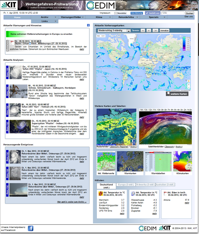 |
Feasible and routinely available techniques will be used to give an advance or real-time estimation of possible damage (amount of loss) before and during a winter storm event over Europe. With accurate station data (wind gusts) at representative locations weighted or unweighted storm indices will be calculated for past storm events. All this calculations eventually lead into a kind of “storm-MOS” (Model Output Statistics) that describes a storm event with reasonable certainty and precision and that allows to evolve a storm damage function. Once the storm occurs, the wind measurements at representative locations on the one hand and the model predicted wind gusts on the other hand provide the storm indices and the appropriate damage index. The data of all past and future storm events will be fed into a database and the parameters are: name, date, regions affected, model data, measurement data and loss data.
|
|
Willis Hail Hazard Assessment
|
|
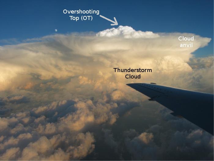 |
A stochastic model for the frequency, extent and severity of hail events has been developed for Europe, and a version covering the Australian continent is currently under development. Research at KIT is focusing on the hazard component of the risk model. European METEOSAT Second Generation (MSG) and Japanese MT-SAT satellite data is used to identify major convective storms associated with hail. The method leads to unique, spatially homogeneous event data set covering entire continents for time periods of more than a decade. Stochastic modelling of the frequency, length, width, and severity of hail events then allows to generate a large event set for hailstorms expected to occur in several thousand years. This event set can in turn be combined with insurance portfolios in order to estimate loss events for certain return periods. The aim of the project is also to improve the understanding of the relationship between the strength of convection and the formation of hail, and more generally the prevailing atmospheric conditions at the formation of hail events. Several other data sources including climate model data are considered in this context.
|