
Project Description
Quantitative instrumental observation of earthquakes began in the 19th century. The first distant earthquake identified in a seismological recording was an earthquake in Japan in 1889 recorded by Ernst von Rebeur-Paschwitz in Potsdam. This recording is exhibited at GFZ German Research Centre for Geosciences, Potsdam. Nowadays, several institutions provide online access to real time epicenter and magnitude estimates, e.g. GEOFON operated by GFZ. The epicenter is defined as the point at the Earth's surface above the location where the earthquake generating rupture process initiates. A more detailed description of an earthquake source includes the distribution and evolution of slip at the fault plane. There are teleseismic methods which are routinely used to track the rupture propagation, but the determination of an absolute value of slip is still very difficult with traditional seismological methods, since these rather see luminosity, that is, how much energy is radiated in the form of seismic waves. Slip can better be assessed by measurements of displacement in the vicinity of the source. Such GNSS or strong-motion accelerometer observations in the near field are not affected by clipping like broadband-seismometers and are available even while the rupture process is still going on, whereas it takes more than 10 minutes for the seismic waves to reach teleseismic distances. However, most studies inverting displacement for slip are based on a static approach for modeling.
The goal of this project is to further develop and implement kinematic inversion techniques using displacement wave forms which include near-field terms in order to obtain a detailed description of the earthquake source within a short amount of time. One application, where rapid determination of slip distribution is crucial, is tsunami early warning. Quick and reliable assessment of earthquake magnitude avoiding saturation is essential for rapid shake-map simulation and loss estimation.
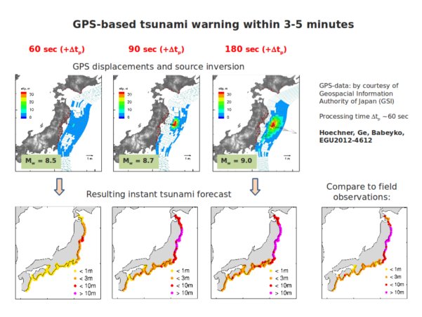 |
| Pic. 1: The illustration shows how GPS might have been used for tsunami early warning in case of the Tohoku earthquake in 2011. The black arrows in the upper panels are surface displacements caused by the earthquake. Advanced GPS processing techniques allow monitoring in near real time. These displacements can be used to invert for the earthquake source process at depth (coloured patches), which in turn allows an estimation of coastal tsunami wave heights (lower panels). The lower right panel contains observational data from a field survey. |