
How is mobility behavior affected by flooding?
Due to climate change, the frequency and intensity of floods is expected to increase. In such situations, affected people can either evacuate or remain in the residential area and adapt their behavior to the crisis situation. The CEDIM project "Effects of extreme events on energy, information and mobility systems“ (Wisotzky, 2023) investigated the mobility behavior for the proportion of the population that has not evacuated in the event of a flood. On the one hand, the insights gained can be used as a basis for making predictions about changes in behavior and estimating the economic costs resulting from changes in mobility behavior. On the other hand, findings can provide a basis for political recommendations for action, for example with regard to precautionary measures. The research question was investigated in a case study in the Laubegast district of Dresden, which is often affected by floods.
Overall, a significant decrease to almost half in traffic volume was observed as a result of a flood, affecting all five trip purposes (work, education, shopping, drop-off/pick-up, leisure). The trip durations increased statistically significantly on average in the flood case, except for leisure trips. In addition, shifts in the importance of the means of transport could be identified: Walking and bicycling gained importance in the flood case, while cars and public transport were less important. Changes in the importance of trip purposes were also observed, although less pronounced than for modes of transport. Work trips gained relative importance, while drop-off and pick-up trips decreased. The shifts in modes and trip purposes turned out to be statistically significant, mostly at α = 5 %. The proportion of trips leading to the local area also increased significantly in the flood case, except for the trip purposes of work and education.
Fig. 1: Changes in the importance of destinations traveled to by district and schematic illustration of changes in the importance of transportation modes shown by the bars in each district.
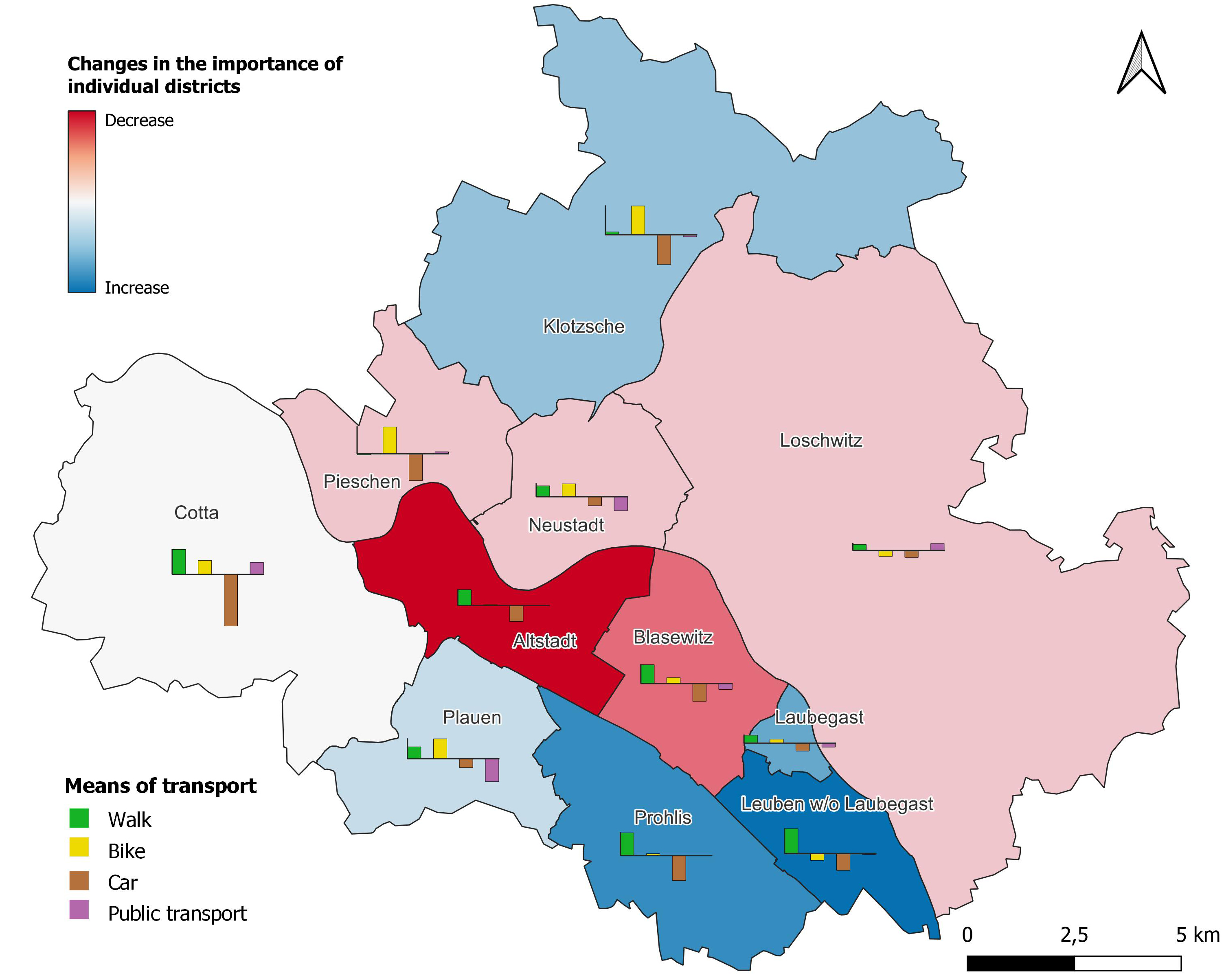
Darüber hinaus wurde untersucht, wie sich die Verteilung der angesteuerten Ziele und die Verkehrsmittelwahl auf Bezirksebene in den beiden betrachteten Fällen unterscheiden. In der Abbildung 1 sind die Veränderungen zwischen Normalfall und Hochwasserfall im Anteil der Wege nach Bezirk und die Unterschiede im Modal Split in den einzelnen Bezirken dargestellt. Zu den im Hochwasserfall stärker angesteuerten Zielen zählen die Bezirke Leuben (zu dem der Stadtteil Laubegast gehört), Prohlis, Plauen und Klotzsche (bläulich dargestellt), während die Bedeutung der übrigen Bezirke rückläufig ist (rötlich dargestellt). Insbesondere verliert der zentrale Bezirk Altstadt, der im Normalfall sehr stark angesteuert wird, massiv an Bedeutung. Der Bezirk Cotta spielt weder im Normal- noch im Hochwasserfall eine große Rolle. Der Anteil der Fußwege (grüner Balken) steigt im Hochwasserfall in fast allen Bezirken an, der Anteil des Pkw (brauner Balken) ist überall rückläufig. Der Fahrradanteil (gelber Balken) ist auch meist ansteigend, während beim ÖV (violetter Balken) je nach Bezirk unterschiedliche Tendenzen zu erkennen sind.
Literatur:
Wisotzky, Ch. (2023): Auswirkungen von Hochwasser auf Mobilitätsverhalten – Eine Untersuchung am Beispiel Dresden-Laubegast, Phd Thesis, Institute of Economics (ECON), Karlsruhe Institute of Technology (KIT), Karlsruhe, doi:10.5445/IR/1000157766.
Associated institute at KIT: Institute of Economics (ECON) – Chair of Network Economics
Autor: Christina Wisotzky (May 2023).