
Exploring hydrological drought events in a large meteorological data set
Hydrological droughts are intricate to predict because they depend on several factors that occur over
extended time periods. However, many studies have focused on determining the propagation from
meteorological to hydrological drought by correlating different drought indices. This process was studied for
a section of the Rhine catchment (Efuhrt et al., 2020). The authors concluded that the hydrological droughts
index in the upper Rhine has a good correlation with the Standard Precipitation and Evapotranspiration
Index (SPEI) for the accumulation periods of three, six and twelve months.
The Large Ensemble of Regional Climate Model Simulations for Europe (LAERTES-EU) data set was used to
assess the findings from Erfurt et al. (2020). LAERTES-EU is comprised of a series of dynamically downscaled
simulations for present day conditions with the COSMO-CLM regional climate model that varied on the
resolution of the boundary conditions and the starting period of the simulation, resulting in 12.000 years of
meteorological information (Ehmele et al., 2020). The surface temperature and precipitation variables were
bias-corrected in a separate project (Ehmele et al., 2022) and used to estimate the SPEI values with a logistic
distribution and a 30-year mean from the data set.
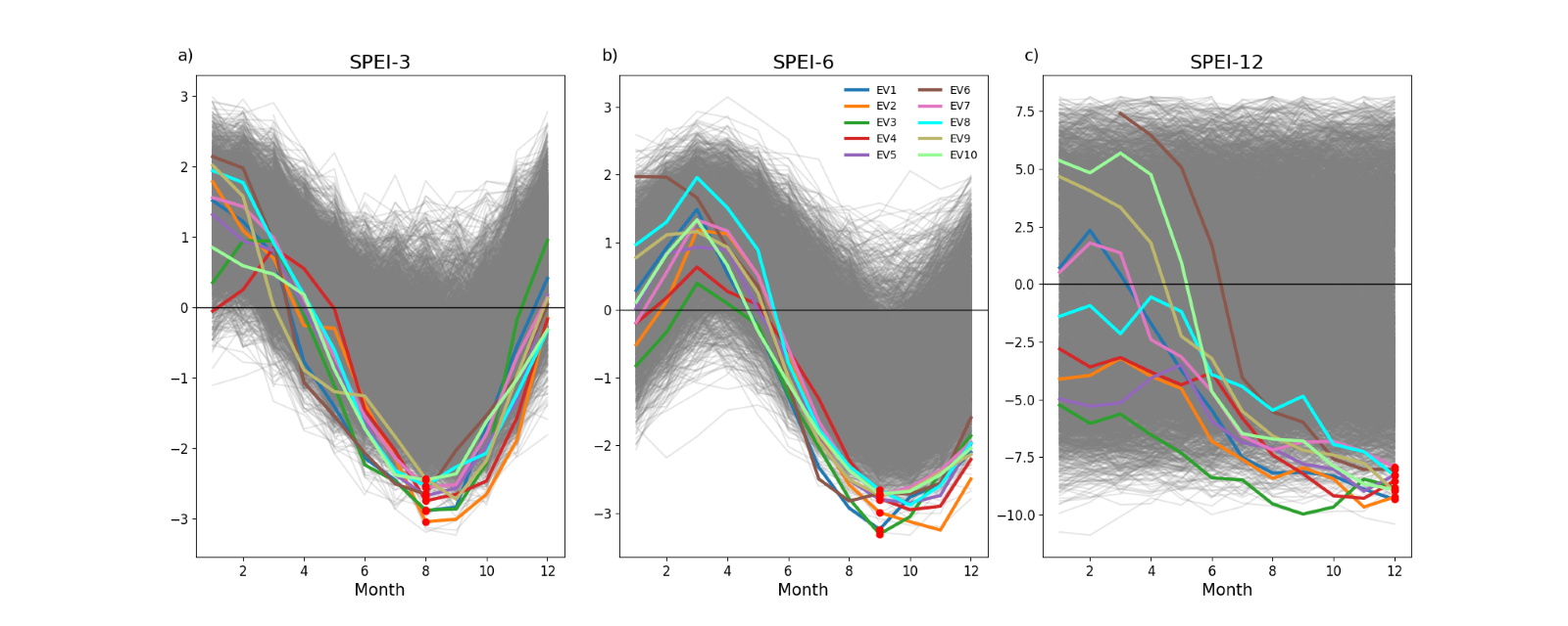
months. The color lines represent the 10 most extreme years; all other years are gray. The red dots are the
minimum SPEI values for ranking the extreme events.
Due to computational constraints, a preselection of cases to assess the potential propagation into
hydrological droughts using WRF-Hydro was necessary. Using a ranking approach, the ten events were
selected that displayed the most severe meteorological conditions based combined extreme SPEI combined
among the accumulation periods of three, six, and twelve months (Figure 1). The selected events were
modeled starting from their previous year as a warmup period, and to consider the catchment’s
preconditions.
The simulated discharges from six main gauges along in the Rhine River were compared to the 2018 drought
event, with a navigation threshold (GlQ20) called equivalent discharge, which is estimated based on a long-
term average of 100-year discharge values (Zentral Kommission für die Rheinschifffahrt, 2014). It is used as a
benchmark to determine whether navigation is possible and if maintenance, e.g. dredging of the riverbed, is
necessary (Federal Waterways Engineering and Research Institute, 2019). The simulated discharge based on
the LAERTES-EU event ranked first based on the SPEI values exhibits values below that of 2018 and for
longer duration of approximately 120 days below GlQ20. Similar results are obtained with the other nine
selected drought events in LAERTES-EU (not shown). From these findings, it can be concluded that the SPEI
is a valid parameter to assess the propagation from meteorological to hydrological drought in the Rhine
River Basin.
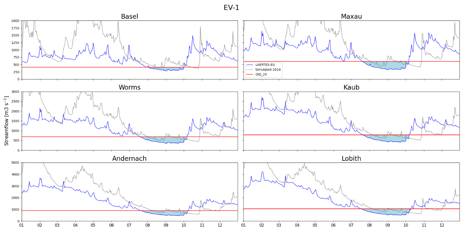
simulated drought in 2018 (gray) at six gauges in the Rhine River Basin. The red line represents the
navigation threshold GlQ20.
References
Ehmele, F., Kautz, L.-A., Feldmann, H., & Pinto, J. G. (2020). Long-term variance of heavy precipitation across
central Europe using a large ensemble of regional climate model simulations. Earth System Dynamics, 11(2),
469–490. https://doi.org/10.5194/esd-11-469-2020
Ehmele, F., Kautz, L.-A., Feldmann, H., He, Y., Kadlec, M., Kelemen, F. D., Lentink, H. S., Ludwig, P., Manful,
D., & Pinto, J. G. (2022). Adaptation and application of the large LAERTES-EU regional climate model
ensemble for modeling hydrological extremes: A pilot study for the Rhine basin. Natural Hazards and Earth
System Sciences, 22(2), 677–692. https://doi.org/10.5194/nhess-22-677-2022
Erfurt, M., Skiadaresis, G., Tijdeman, E., Blauhut, V., Bauhus, J., Glaser, R., Schwarz, J., Tegel, W., & Stahl, K.
(2020). A multidisciplinary drought catalogue for southwestern Germany dating back to 1801. Natural
Hazards and Earth System Sciences, 20(11), 2979–2995. https://doi.org/10.5194/nhess-20-2979-2020
Federal Waterways Engineering and Research Institute (2019). Equivalent water level.
https://wiki.baw.de/en/index.php/Equivalent_water_level. Access: 01.04.2025
Zentralkomission für die Rheinschifffahrt. (2014). Herbstsitzung 2014 Angenommene Beschlüsse (2014-II).
https://www.ccr-zkr.org/files/documents/resolutions/ccr2014_IId.pdf
Associated institute at KIT: Institute of Meteorology and Climate Research Troposphere Research (IMKTRO)
Author(s): Andrea Campoverde Márquez, Patrick Ludwig (May 2025)