
Where in South America does hail occur?
↵
Although large hail usually only occurs very locally, it is responsible for a significant portion of the weather-related damages worldwide. Therefore, insurance companies need reliable estimates of the spatial distribution and frequency of hail. In cooperation with WillisRe, GallagherRe, and NASA, the project Willis Hail Hazard Assessment estimates the hail risk for South America. Although some of the strongest thunderstorms worldwide occur in South America (Bang and Cecil 2019), hail risk have only recently been intensively studied there (see, for example, Nesbitt et al. 2021).
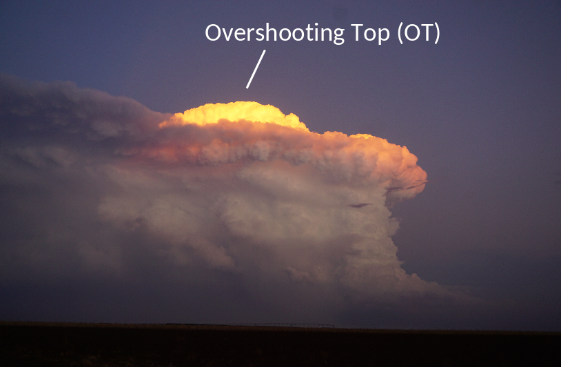
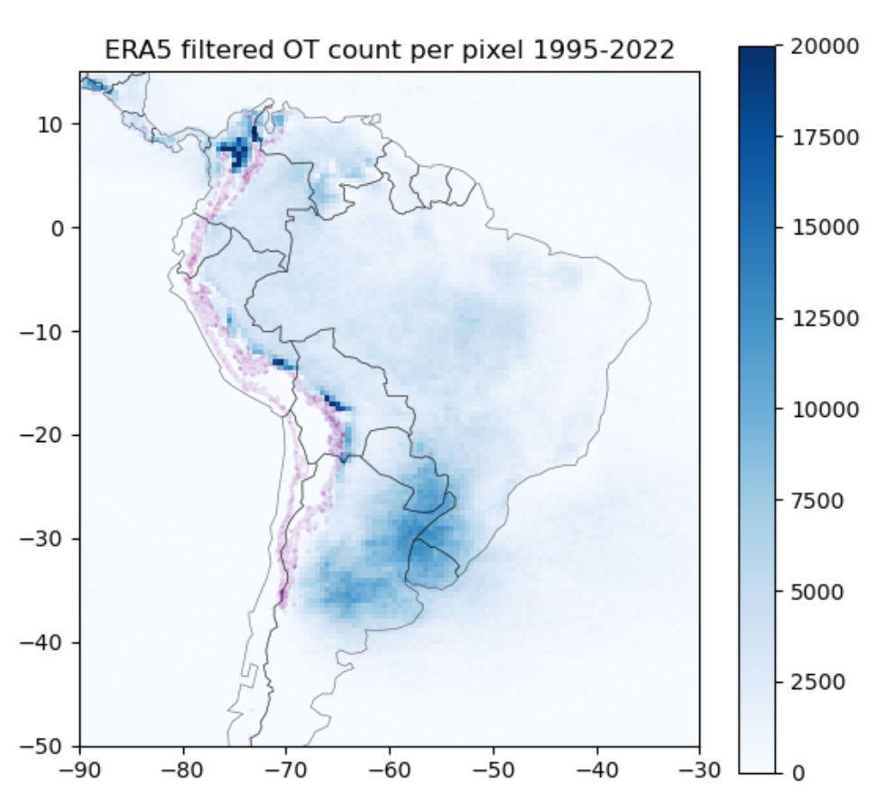
The project is based on satellite data, with which the tops of particularly strong thunderstorms, so-called overshooting tops (OT), can be detected (Fig. 1). Corresponding algorithms were developed by the collaborative partner NASA Langley, Kris Bedka and colleagues and have been perfected for over a decade (Bedka et al. 2010, Khlopenkov et al. 2021). The OTs are then filtered according to the environmental conditions that favor hail (see, for example, Punge 2014). The result is an estimate of the spatial distribution of hailstorms (Fig. 2). One can see the well-known center of severe thunderstorms in northern Argentina, southern Brazil, Uruguay, and Paraguay, as well as isolated small hotspots at the edge of the Andes and occasional, weak activity in the rest of the tropical lowlands.
The method described is scientifically tested (Scarino et al. 2023) and has already proven its worth in other regions such as Europe, Australia, and South Africa (Punge et al. 2017, Bedka et al. 2021, Punge et al. 2018). In the case of South America, a particularly long data series of 28 years of satellite observations is available. This, as well as the now improved spatial and temporal satellite resolution, allows the analysis of further details on hail in South America. For example, the project also estimates the return period of certain hail sizes. Large hail, for example, is most common in northern Argentina, where a hail event with a maximum diameter of 5 cm is to be expected every 10 years. The influence of climate change on the frequency of hail can also be narrowed down using the data, which is currently being worked on.
References:
- Bang, S. D., D. J. Cecil (2019): Constructing a Multifrequency Passive Microwave Hail Retrieval and Climatology in the GPM Domain. J. Appl. Meteor. Climatol., 58, 1889–1904, doi:10.1175/JAMC-D-19-0042.1.
- Bedka, K., Brunner, J., Dworak, R., Feltz, W., Otkin, J., Greenwald, T. (2010): Objective Satellite-Based Detection of Overshooting Tops Using Infrared Window Channel Brightness Temperature Gradients, J. Appl. Meteorol. Clim., 49, 181–202, doi:10.1175/2009JAMC2286.1.
- Bedka, K. M., Allen, J. T., Punge, H. J., Kunz, M., Simanovic, D. (2018): A Long-Term Overshooting Convective Cloud Top Detection Database Over Australia Derived From MTSAT Japanese Advanced Meteorological Imager Observations. J. Appl. Meteorl. Climatol., doi:10.1175/JAMC-D-17-0056.1.
- Khlopenkov, K. V., Bedka, K. M., Cooney, J. W., Itterly, K. (2021): Recent Advances in Detection of Overshooting Cloud Topsfrom Longwave Infrared Satellite Imagery, J. Geophys. Res.-Atmos., 126, e2020JD034359, doi:10.1029/2020jd034359.
- Nesbitt, S. W., Coauthors, 2021: A Storm Safari in Subtropical South America: Proyecto RELAMPAGO. Bull. Amer. Meteor. Soc., 102, E1621–E1644, doi:10.1175/BAMS-D-20-0029.1.
- Punge, H.J., Bedka, K.M., Kunz, M., Reinbold, A. (2017): Hail frequency estimation across Europe based on a combination of overshooting top detections and the ERA-INTERIM reanalysis, Atmos. Re., 198,34–43, doi:10.1016/j.atmosres.2017.07.025.
- Punge, H. J., Bedka, K. M., Kunz, M., Bang, S. D., Itterly, K. F. (2023): Characteristics of hail hazard in South Africa based on satellite detection of convective storms, Nat. Hazards Earth Syst. Sci., 23, 1549–1576, doi:10.5194/nhess-23-1549-2023.
- Scarino, B., K. Itterly, K. Bedka, C.R. Homeyer, J. Allen, S. Bang, D. Cecil (2023): Deriving Severe Hail Likelihood from Satellite Observations and Model Reanalysis Parameters using a Deep Neural Network, Artificial Intelligence for the Earth Systems, doi:10.1175/AIES-D-22-0042.1.
Associated institute at KIT: Institute of Meteorology and Climate Research (IMK-TRO)
Author: Jannick Fischer (Aug. 2023)