

Identifying systematic climate risks and improving adaptation in communities
Rural communities in Germany are facing a dual challenge: not only must they adapt to long-term climate change and increasingly frequent extreme weather events, but they must also do so with limited financial and human resources. Previous climate risk assessments in municipalities have often focused on specific issue areas, such as agriculture or infrastructure. Consequently, they rarely consider the interconnected relationships between social, economic and environmental factors. A new semantics- and GIS-based model developed by the Institute for Industrial Production (IIP) at KIT provides a scientifically robust and practical approach to systematically assessing climate risks in rural regions and developing effective adaptation strategies. Using modern network analysis, the model demonstrates how climatic influences can affect and spread across different areas of a municipality, identifying where critical connections are particularly important. By combining geographic data, including both climate and socio-economic data, these impacts can be made visible on a map, enabling targeted measures to be planned. Previous climate risk assessments in municipalities have often focused on individual issue areas, such as agriculture or infrastructure.
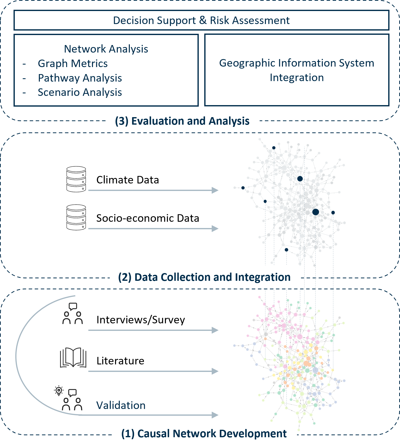
The model uses three key components to make the impact of climate change on rural areas tangible:
- Systemic modelling
By representing the community as a network of interactions, the model reveals the influence of climate factors, as well as the interaction between infrastructure, social systems, and the economy. This causal network was developed based on literature reviews and interviews/surveys, and was then validated by local experts (see link). To analyse this network of effects, graph metrics are combined to identify key nodes in the network and structural dependencies (see DKKV Lunchtalk).
- Data integration and normalisation
Selected nodes representing municipal characteristics (e.g. population figures) are linked to real municipal data and embedded in the overall framework. Climatic influences are also supported by specific raster data (e.g. the number of hot days) from various climate scenarios. Normalizing the data to a common scale enables indicators from different areas to be compared directly.
- Spatial analysis
The causal relationships from the municipal impact framework are visualised spatially for selected nodes (particularly the key nodes from the graph-metric analysis) in geographic information systems (GIS), using stored data on climatic and socio-economic boundary conditions. This makes it possible to identify where conditions are particularly favourable for the node in question, how these conditions will change due to future climate developments, where potential risks might arise and where there is a corresponding need for adaptation. Similarly, incorporating adaptation measures into the impact framework allows their effects to be compared.
The results of the spatial analysis show that climate adaptation measures must be selected and coordinated carefully in order to address multiple impact areas. Isole and seasonally focused measures (such as artificial snowmaking in winter to promote winter recreational opportunities) will not suffice in the long term. Spatial analysis can provide valuable support in determining whether and to what extent the measures under consideration can contribute to the intended objective (e.g. creating favourable conditions for residential areas and improving quality of life).
The initial results of the model were presented at the International Conference on Resilient Systems in Delft in spring 2026 (Hofmann et al., 2026). This case study focuses on the city of Freudenstadt, which, alongside VKU as an associated partner, is participating in the BMBF-funded collaborative project LandWandel. Project partners include Stadtwerke Freudenstadt and KIT's South German Climate Office.
Associated institut at KIT: Institute for Industrial Production (IIP) (IIP)
Autors: Sonja Rosenberg, Ines Hofmann, Frank Schultmann (July 2026)
Reference: Hofmann, I.; Rosenberg, S.; Schultmann, F. (2026); Systemic Climate Risk Mapping in Rural Municipalities: A Semantic-GIS Framework for Vulnerability Assessment and Resilience Planning; International Conference on Resilient Systems, (ICRS), 2026, Delft, The Netherlands : Book of Abstracts. Ed.: T. Comes, 263–268, Technische Universität Eindhoven (TU Eindhoven); https://doi.org/10.6100/qp5f-nb93.